
Home » Regions » North America » Northwestern Forested Mountains » Boreal Cordillera » Yukon-Stikine Highlands/Boreal Mountains and Plateaus
Yukon-Stikine Highlands/Boreal Mountains and Plateaus
Last updated: November 6th, 2023
Page contents
↑About the Yukon-Stikine Highlands/Boreal Mountains and Plateaus
The Yukon-Stikine Highlands/Boreal Mountains and Plateaus is a mountainous region at the far north of interior British Columbia, extending slightly into southwestern Yukon.The climate here ranges from a dry-summer subarctic climate in the west, to a regular subarctic climate in the east, and an arctic / tundra climate at high elevations. The climate in the west is more moderate overall, but winters are drier. The east of the region has more continental influence, with larger temperature extremes and more change in week-to-week weather patterns. Although precipitation increases with altitude, this increase is smaller than in areas farther south, as the higher elevations here get so cold that the air cannot hold much moisture, especially in winter.
The terrain here alternates between rugged mountains, plateaus, and broad but irregularly hilly bottomlands. This region was recently glaciated so the drainage network is disrupted and the terrain is weakly dissected. There are numerous small lakes and wetlands throughout the bottomlands, and some at higher elevations as well. Permafrost can be found here in isolated pockets in the north and southwest of the region. This region spans major watershed divides, with the Liard, Stikine, and Fraser rivers draining different portions of the land. The Liard river flows east out of this region, eventually draining into the Arctic, whereas the Stikine flows southwest into the Pacific, and the Fraser southeast, eventually also into the Pacific but after a much longer trip.
The vegetation cover changes dramatically with small changes in elevation and slope aspect. Lower elevations and warmer sites feature closed-canopy boreal forests of lodgepole pine (Pinus contorta), white spruce (Picea glauca), and black spruce (Picea mariana). Slightly higher-elevation and cooler sites feature more open forests of subalpine fir, white spruce, and shrubby growth of willow and birch. Just above the tree line are meadows featuring dwarf shrubs of willow and birch, grasses, sedge, and mountain avens (Dryas sp.). These give way to rock outcroppings covered in lichens.
This region is sparsely populated. The main land uses in the mountains are hunting, trapping, and recreation. There is a small amount of forestry and forage crop production in the valleys, as well as a small amount of mining, including of gold. The largest settlements is Atlin, BC, with a permanent population under 500, and there are a few other even smaller towns including Dease Lake, BC, Carcross, YT, and Muncho Lake, BC. The population of this area increases in summer.
This region is bordered to the north by the Watson Highlands, a similar but colder region with a higher density of permafrost and more open forest cover; this border is subjective and represents a gradual transition rather than a clear geographic divide. At the far northwest, there is a border to the west with the Wrangell and St. Elias Mountains, a high-elevation, presently glaciated region; this border is abrupt and well-defined. To the south, this region borders the Skeena-Omineca-Central Canadian Rocky Mountains, in another subjective border representing a gradual transition. To the east, this region borders the lower, flatter Hay and Slave River Lowlands of the Taiga Plain.
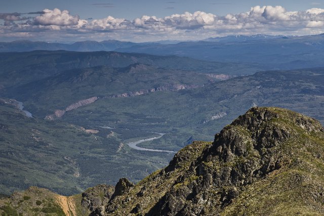 This photo taken near Glenora, British Columbia, overlooking the valley of the Stikine River, shows terrain in the Yukon-Stikine Highlands/Boreal Mountains and Plateaus, which ranges from rugged mountains to irregularly hilly bottomlands. Forest cover is greatest at lower elevations and opens to barren rock at the highest elevations. Photo © Ethan Reitz, CC BY 2.0, Source.