
Home » Regions » North America » Mediterranean California » Southern California Mountains
Southern California Mountains
Last updated: November 10th, 2023
To check where a specific point lies, you can look it up in our Ecoregion Locator.
↑Map Legend & Subregion List
This list will help you navigate the regions in case you have problems with viewing or clicking the interactive map above.
† Status: ✓ = Complete ○ = Needs Image … = Incomplete ∅ = Stub Only
‡ This code refers to the US EPA's Level 4 ecoregion codes for the continental U.S., see here.
↑Progress
Partially Complete | With Images | Complete w/ Images |
Get involved! You can help our ecoregion articles progress faster. Help us find photos of these regions. Contact us if you have any additions or corrections to any of these articles. You can also donate to support our ongoing work.
↑About the Southern California Mountains
The Southern California Mountains, also referred to in some documents as Southern and Baja California Pine-Oak Mountains (Montañas con bosques de pino y encino de Baja California y sur de California) are an area of mountains including both the transverse range (Santa Ynez, San Gabriel, and San Bernardino mountains) and the Peninsular range (San Jacinto Mountains, Laguna Mountains, Sierra Juárez, and Sierra San Pedro Martír.) Towards the south end of the Peninsular range, this region only includes scattered, discontiguous, higher-elevation areas, whereas in the north this area is more extensive and contiguous.The average climate here is a mild, semi-arid Mediteranean climate, but varies considerably by elevation and orientation relative to the topography. The climate tends towards a desert climate at lower elevations in the south and on the eastern side of the ranges; near the ocean temperatures are mild and humidity and cloud cover are higher, but rainfall is low. At higher elevations, precipitation increases significantly, summers become hotter, and winters colder; the highest elevations reach a dry-summer subarctic climate with cool summers and cold winters with extensive snowfall. Summers are thus hottest at mid-elevations. Low elevations are nearly frost-free whereas high elevations can experience frost during nearly two-thirds of the year, and experience significant snowfall, with snow cover often persisting into warmer months but eventually melting. The higher total precipitation supports more tree growth than can be found elsewhere in southern California uplands.
The terrain here is irregular, with high, steep, and narrow mountain ranges, some plateaus, and narrow valleys filled with coarse sediments originating uphill. Faulting and earthquakes have broken up the landscape, and many slopes are unstable, subject to landslides and other forms of mass wasting.
Vegetation cover is diverse, changing extensively with elevation. Low elevations feature chaparral with chamise (Adenostoma fasciculatum) and scrub oak (Quercus berberidifolia). Slightly above this are open woodlands with ceanothus, manzanita, pinyon, and juniper. Middle elevations feature open coniferous forests, with sugar pine (Pinus lambertiana), white fir (Abies concolor), jeffrey pine (Pinus jeffreyi), ponderosa pine (Pinus ponderosa), and juniper. The highest elevations feature subalpine forests of lodgepole pine (Pinus contorta) and limber pine (Pinus flexilis). Tree growth throughout is still moisture-limited, leading forests to be open and tree height and density to be higher in sheltered ravines and north-facing slopes and lower on exposed and south-facing slopes. Because of a combination of rain shadow and hot, dry air from interior desert areas, dry scrubland extends to higher elevations near the north and east borders of this region than in the south and west, and this scrubland is sparser than chaparral on the coastal side. Forest fires are common throughout, and usually occur in late summer, but can rarely occur at other times of year as well.
This is the least-developed area of Mediterranean California, owing to its steep topography. There is some forestry, a small amount of agriculture and rural residential development, and some recreation and tourism. Much of the area is preserved in national forests. This region is also important in water supply, particularly of the Los Angeles metro area; there are several reservoirs constructed by damming and used for this purpose. Most of the region is sparsely populated and there are no formally-recognized cities, but there are some unusually large unincorporated communities, particularly where this region intersects San Bernardino County. The largest such communities are Lake Arrowhead and Big Bear City (both over 12,000 people), followed by Crestline (over 10,000), Wrightwood, and Running Springs. The portion of this region in Mexico is even more sparsely populated; the largest town is La Rumorosa, Baja California.
From the 1930's until recently, the US Forest Service carried out a strict policy of fire suppression here, aiming to extinguish all fires by the next day. This resulted in many years of fuel accumulation in an ecosystem unaccustomed to such accumulation. Eventually, this policy led to an increase in highly destructive, severe fires. In recent years, this policy has shifted towards carrying out controlled burns.
This area extends to the coast in a small area. In most areas though it is bordered to the west by the California Coastal Sage, Chaparral, and Oak Woodlands. To the east it is bordered by the Mojave Basin and Range, produced in large part by the rain shadow from these mountains. Farther south, it is surrounded at lower elevations by the Coastal Sage, Chaparral, and Oak Woodlands, and does not directly border desert, although moving east not far one finds the Sonoran Basin and Range.
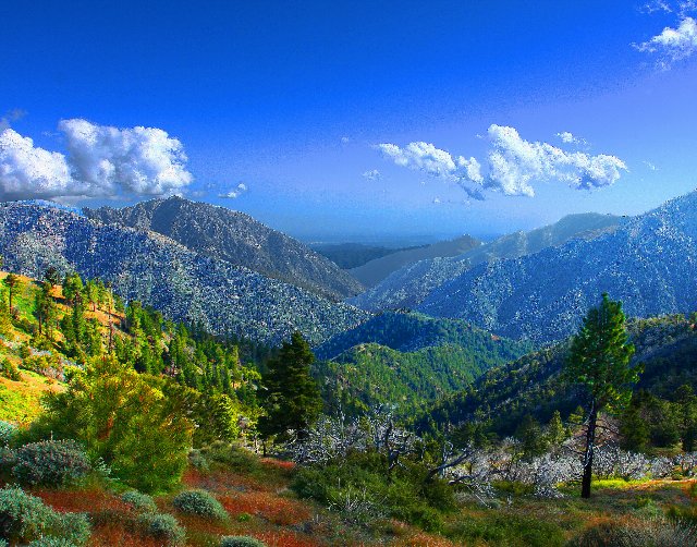 This colorful landscape in the San Gabriel Mountains shows typical vegetation cover of middle elevations in the Southern California Mountains, with extensive but irregularly open coniferous forests. The terrain tends to be rugged and steep. Photo © Rennett Stowe, CC BY 2.0, Source.
Plant Lists & In-Region Search
List Native Plants - List All Plants
Warning! This region extends outside the lower 48 US. We have only completed range maps for all plants in the lower 48 US; these lists and searches may thus have omissions for species which only occur in the portion of this region outside the lower 48 US.
↑References
1. Wiken, E., Griffith, G. "North American Terrestrial Ecoregions - Level III", Commission for Environmental Cooperation, (2011) Web.