
Home » Regions » North America » Eastern Temperate Forests » Central USA Plains » Huron/Erie Lake Plains » Maumee Lake Plain
Maumee Lake Plain
Last updated: January 22nd, 2021
Page contents
↑About the Maumee Lake Plain
The Maumee Lake Plain is a region that extends along the western shores of Lake Erie, in northwest Ohio and southeastern Michigan, and barely into northeastern Indiana. It contains most of the Detroit and Toledo metro areas and has heavy urbanization, including both industrial and residential development. Away from the cities, it has been heavily altered through draining and agriculture. This is one of the most severely altered and degraded ecoregions in North America.This region is covered by fine-grained glacial till and lake sediments, with some coarser deposits originating as terminal moraines and beach ridges. The underlying bedrock is limestone and dolomite, which is occasionally exposed at the surface. This region has soils that are highly fertile, but poorly-drained.
Natural forest cover was mostly elm-ash swamp forest, with American elm (Ulmus americana), green ash (Fraxinus pennsylvanica), and black ash (Fraxinus nigra) as dominants. Better-drained sites supported forest of American beech (Fagus grandifolia). Dolomite ridges and areas with more sand and silt supported scattered mixed oak forests, with black oak (Quercus velutina), bur oak (Quercus macrocarpa), white oak (Quercus alba), and scarlet oak (Quercus coccinea) as dominant species. There were also fens along part of the Lake Erie shoreline, and scattered wet prairies.
This area has been severely altered by artificial drainage, both for agriculture and urbanization. 80-90% of the wetlands in the region have been destroyed, and remaining marshes have been degraded by silt and erosion. This area has a long history of farming and was one of the first areas of Michigan to be cleared and cultivated as European settlers moved west. The area remains one of the most productive in the region, and now produces corn, soybeans, and livestock. The milder climate along the lake also creates an environment attractive for vegetable production, including tomatoes, sugar beets, beans, and cucumbers. Little forest cover remains; most remaining forest is in the form of small, isolated woodlots, separated from each other by long distances. Outside of woodlots there is a small amount of bottomland hardwood forest and black ash swamp on sites where drainage attempts were ineffective. Recently, ash has been mostly eliminated by the Emerald Ash Borer, and previously, elm was greatly reduced by Dutch elm disease; bottomland forests nowadays have a very different composition. The mixed oak forests on drier sites have been almost completely eliminated.
Interspersed throughout this region are numerous Oak Openings, a sandier region that is somewhat more forested. Most of this region is bordered to the west and south by the Clayey High Lime Till Plains, a heavily agricultural region that is less urbanized than this one. This border is well-defined; the northwestern border with this region in Michigan is marked by an end moraine. In the far north, this region is bordered to the northwest by the Interlobate Dead Ice Moraines and to the north by the Saginaw Lake Plain; the border to the north is more arbitrary and represents a gradual transition based on climate. In Ohio, this region is bordered to the east along Lake Erie by the Marblehead Drift/Limestone Plain, and the western part of this region surrounds the Paulding Plains.
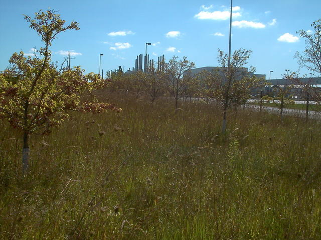 This photo shows a wetland near the Ford Rouge Factory in Dearborn, Michigan. Such a mix of industry with small remnant wetland fragments, is common in the Maumee Lake Plain, a heavily industrialized region where most of the wetlands have been drained. Photo © Scott Monty, CC BY-SA 2.0, Source.
Plant Lists & In-Region Search
We do not yet have data to generate plant lists for a region as fine-tuned as this one. However you can move up to the broader Huron/Erie Lake Plains and generate lists for that region: native plants or all plants. Or search that region's plants here:
↑References
1. Woods, A.J, Omernik, J.M., Brockman, C.S., Gerber, T.D., Hosteter, W.D., Azevedo, S.H. "Ecoregions of Indiana and Ohio (Poster)", US Geological Survey (1998) Web.
2. Omernik, J.M., Bryce, S.A. "Michigan: Level III and IV Ecoregion Descriptions / Mapping Issues", US EPA (2007) Web.