
Home » Regions » North America » Eastern Temperate Forests » Central USA Plains » Huron/Erie Lake Plains » Saginaw Lake Plain
Saginaw Lake Plain
Last updated: August 13th, 2020
Page contents
↑About the Saginaw Lake Plain
The Saginaw Lake Plain is a region located entirely within Michigan, including the "thumb" region of Michigan's lower peninsula, and extending along Saginaw Bay and significantly south and west from the thumb and bay. It can be seen as a more northerly continuation of the Maumee Lake Plain to the south, but bordering Lake Huron.The region is mostly flat, underlain by clayey lake deposits, with some beach ridges and low dunes. Although there is some sand associated with beach formations, the soils are mostly poorly-drained, although not as much as regions farther south.
The region has a humid continental climate. During the summer, the lake significantly cools the climate in the thumb region, especially near the lake, whereas the more inland western portion of the region has warmer summers. In the coldest periods of winter, there is significant ice cover on the lake, which reduces the lake-effect snow as well as the moderating effect of the lake.
Original forest cover consisted of hemlock-Northern hardwood associations, with eastern hemlock (Tsuga canadensis), American beech (Fagus grandifolia), and sugar maple (Acer saccharum) as dominant trees. Drier beach ridges featured eastern hemlock and eastern white pine (Pinus strobus). Sandy, drier sites farther inland featured red pine (Pinus resinosa), eastern white pine, white oak (Quercus alba), and black oak (Quercus velutina). Poorly-drained sites featured conifer swamps of northern white-cedar (Thuja occidentalis), tamarack (Larix laricina), and balsam fir (Abies balsamea) intermixed with moisture-loving hardwood species such as elm, ash, and swamp white oak (Quercus bicolor). Relative to the lake plains to the south, this region had fewer oaks, and more pines, hemlock, and conifer swamps. In addition to forests, there was a broad band of coastal marshes and wet prairies lining Saginaw bay.
The original forests have been entirely cleared. What forest cover remains is a very different earlier-successional community, including aspen, black cherry (Prunus serotina), tamarack or larch, paper birch (Betula papyrifera), and red maple (Acer rubrum).
Sites with clay soils have been extensively drained and cultivated for agriculture, which produces corn, soybeans, white beans, and sugar beets, as well as dairy and livestock. In the agricultural areas though, there are only small, isolated woodlots. A smaller portion of the sand plains and beach ridges have been drained and cultivated, due to a combination of their poor suitability to agriculture and high risk of erosion. The northwestern part of this region has large, unbroken tracts of forest, and an even broader region that is mostly forested but where the forests are fragmented by a grid of roads and scattered residential development.
This region is mostly sparsely populated, although there are the smaller cities of Midland and Saginaw, and numerous smaller towns.
In the east, the southern border of this region with the Maumee Lake Plain represents a gradual transition and is somewhat arbitrary; it has been drawn south of the Black River so as to keep its watershed intact. However there is also a change in soil type, with finer-grained soils to the south. Most of this region is bordered to the west and south by the Lansing Loamy Plain, and in the east there is a small border to the southwest by the Interlobate Dead Ice Moraines. Both of these borders are well-defined and marked by topographic changes associated with terminal moraines. To the north, this region is bordered by the Tawas Lake Plain in another gradual transition marked more by a cooler climate and associated changes in soils and ecosystems.
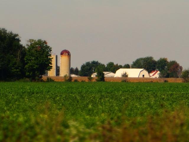 A flat landscape, mostly dominated by farms, with a small woodlot on the left, is typical of most of the Saginaw Lake Plain. This is a crop of a Photo © Ken Lund, CC BY-SA 2.0, Source.
Plant Lists & In-Region Search
We do not yet have data to generate plant lists for a region as fine-tuned as this one. However you can move up to the broader Huron/Erie Lake Plains and generate lists for that region: native plants or all plants. Or search that region's plants here:
↑References
1. Omernik, J.M., Bryce, S.A. "Michigan: Level III and IV Ecoregion Descriptions / Mapping Issues", US EPA (2007) Web.