
Home » Regions » North America » Eastern Temperate Forests » Southeastern USA Plains » Northern Piedmont » Trap Rock and Conglomerate Uplands
Trap Rock and Conglomerate Uplands
Last updated: March 27th, 2025
↑About the Trap Rock and Conglomerate Uplands
The Trap Rock and Conglomerate Uplands, also called the Diabase and Conglomerate Uplands, represents the most rugged and upland portions of the Northern Piedmont. It exists in numerous discontinuous pieces of irregular shape, mostly interspersed throughout the Triassic lowlands, but in a few places bordering the Piedmont Uplands or the Limestone/Dolomite Lowlands.This region consists of steep, rocky hills and ridges composed of a mixture of diabase, a type of trap rock, with sedimentary rocks and and heat-altered variants of these rocks. The diabase represents an igneous intrusion through older triassic conglomerates and reddish sandstones; these magma intrusions heated the sedimentary rocks, making them harder, denser, and less porous. Both the diabase itself, and the altered sedimentary rocks are highly resistant to erosion. A famous diabase ridge is Cemetery Ridge in Gettysburg. Over diabase, the soils are fine, clayey, shallow, and often alkaline. Regions with these soils have a distinct flora marked by a complete absence of acid-loving species.
This region was originally mostly forested, but there were some areas of grassland on the drier slopes, as well as exposed talus slopes, steep slopes of rock fragments. On ridgetops and upper slopes, mixed oak forest featured northern red oak (Quercus rubra), white oak (Quercus alba), and black oak (Quercus velutina) along with sugar maple (Acer saccharum), sweet birch (Betula lenta), white ash (Fraxinus americana), and tuliptree (Liriodendron tulipifera), with an understory of mapleleaf viburnum (Viburnum acerifolium), eastern poison ivy (Toxicodendron radicans), catbrier (Smilax sp.), and wild grape (Vitis sp.). Ravines and north-facing slope featured eastern hemlock (Tsuga canadensis) and various hardwoods. Dry slopes featured chestnut oak (Quercus montana), northern red oak (Quercus rubra), eastern redcedar (Juniperus virginiana), hickories (Carya sp.), and in some areas, grassland openings with little bluestem (Schizachyrium scoparium) and indiangrass (Sorghastrum nutans). Talus slopes, where trees were able to grow, supported eastern hemlock, paper birch (Betula papyrifera), sweet birch, eastern white pine (Pinus strobus), and American basswood (Tilia americana).
Land use is generally less intensive than its surroundings, even in the parts of this region near major metro areas. Areas with soil formed on diabase are poorly-suited to agriculture, although they are sometimes used for grazing. Other parts of this region have soils more suitable for agriculture, and there is some general farming farther from the diabase intrusions. Most of the region is sparsely populated due to its steepness and being surrounded by flatter areas nearby that are more suitable for building. However, where this region is largest in Pennsylvania, in southern Berks County, northeastern Lancaster county, and northwestern Chester County, it contains a few towns, including Adamstown and Mohnton, and the historic village of Saint Peters, which has its origin in the mining and quarrying of diabase. This same area also contains the largest contiguous forest in southeastern Pennsylvania, Hopewell Big Woods, which spans about 73,000 acres (114 square miles.) In the north of this region, where it is almost entirely surrounded by residential development associated with New York, it is utilized for recreation and urban parks.
Overall, this region has the highest portion of forest cover within the Northern Piedmont.
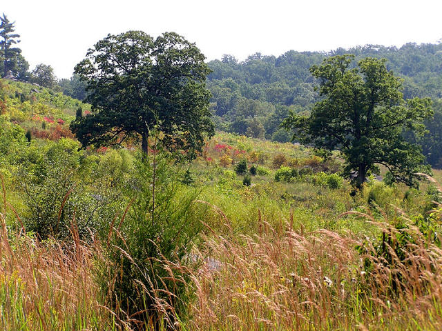 Cemetery Ridge in Gettysburg, PA, is the most famous area within this region; it has topography typical of the region, fairly steep and standing out against the mostly flatter surroundings. Plant growth here is often stunted, but markedly different from the plant communities that form in most other thin-soil regions. Photo © lcm1863 (Flickr), CC BY-ND 2.0.
Plant Lists & In-Region Search
We do not yet have data to generate plant lists for a region as fine-tuned as this one. However you can move up to the broader Northern Piedmont and generate lists for that region: native plants or all plants. Or search that region's plants here:
↑References
1. Woods, A.J., Omernik, J.M., Moran, B.C. "Level III and IV Ecoregions of New Jersey", (2007) Web.
2. Woods, A.J, Omernik, J.M., Brown, D.D. "Level III and IV Ecoregions of Delaware, Maryland, Pennsylvania, Virginia, and West Virginia", U.S. Environmental Protection Agency: National Health and Environmental Effects Research Laboratory, Corvallis, OR (1999) Web.
3. Bryce, S.A., Griffith, G.E., Omernik, J.M., Edinger, G., Indrick, S., Vargas, O., and Carlson, D. "Ecoregions of New York (Poster)", U.S. Geological Survey (2010) Web.