
Home » Regions » North America » Eastern Temperate Forests » Ozark, Oauchita-Appalachian Forests » Central Appalachians » Greenbrier Karst
Greenbrier Karst
Last updated: February 24th, 2021
Page contents
↑About the Greenbrier Karst
The Greenbrier Karst is a small, irregularly-shaped area at the southeasternmost border of the Central Appalachians, roughly near the "elbow" of the region where it angles from moving more east-west to moving more north-south. It is located almost completely within West Virginia, except for a tiny piece in Virginia owing to the irregular border of the states not following the major geographic features of the area.This region is a rolling lowland with isolated hills, surrounded by more rugged areas of higher elevation. Karst topography is abundant, reflecting an underlying substrate of mostly limestone with a small amount of shale. Surface streams are few, and there are sinkholes and underground streams. Subsurface flows feed the Greenbrier river, which flows southwest through the northwestern part of this region, eventually curving to flow northwest out of this region and into the New River.
Among the parts of the eastern U.S. where limestone bedrock and karst topography are dominant, this is one of the most rugged regions. Crests range from 1,800 to 2,900 ft (549-884m) in elevation. Local relief can be as high as 1000ft (305m) where rivers cut through higher ridges, although in most areas the difference between valley bottoms and hilltops is between 150 and 650 ft (46-198m.)
This region has a humid subtropical climate, milder than most of the Central Appalachians, reflecting lower average elevations. Precipitation is somewhat evenly distributed throughout the year, although it peaks in June and fall through winter tend to be slightly drier.
Originally, this area was covered in oak/hickory forest, contrasting with the mixed mesophytic forest in adjacent regions. By 1938, most of the forests had been cleared for agriculture, and remaining forests consisted mostly of white oak (Quercus alba), northern red oak (Quercus rubra), and sugar maple (Acer saccharum), found on steep slopes. Nowadays, there is greater forest cover but still significant agriculture, particluarly pastureland. This area is among the areas of West Virginia most heavily-utilized for agriculture, and it is one of the state's main livestock-producing areas. Much of the region is kept as permanent pastureland, supporting cows for both beef and dairy, sheep, and poultry.
There are no large cities in this region, but the largest city is Princeton, WV, followed by Athens, WV. These cities are considered part of the Bluefield, WV metro area, which extends outside this region. Overall this region is sparsely populated, but denser than more rugged areas to the northwest.
This region has an irregular border to the north with the Forested Hills and Mountains and to the west with the Dissected Appalachian Plateau. Where it is not also surrounded by the Forested Hills and mountains on both sides, this region borders the Northern Dissected Ridges and Knobs to the southeast, except in a small area in the southwest where it borders the Southern Sandstone Ridges to the south, and is also partly surrounded by the Dissected Appalachian Plateau.
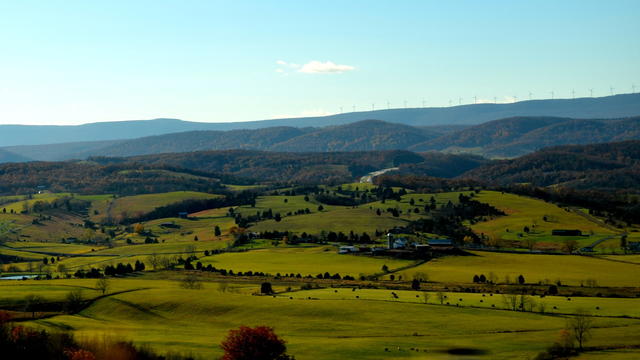 This photo taken near Union, WV shows a landscape typical of the Greenbriar Karst: rolling plains and low hills with few surface streams and abundant agriculture, an island of flatter, more agricultural areas among more mountainous surroundings. Photo © Raman Patel, CC BY 3.0, Source.
.jpg)
Plant Lists & In-Region Search
We do not yet have data to generate plant lists for a region as fine-tuned as this one. However you can move up to the broader Central Appalachians and generate lists for that region: native plants or all plants. Or search that region's plants here:
↑References
1. Woods, A.J, Omernik, J.M., Brown, D.D. "Level III and IV Ecoregions of Delaware, Maryland, Pennsylvania, Virginia, and West Virginia", U.S. Environmental Protection Agency: National Health and Environmental Effects Research Laboratory, Corvallis, OR (1999) Web.