
Home » Regions » North America » Eastern Temperate Forests » Ozark, Oauchita-Appalachian Forests » Central Appalachians » Forested Hills and Mountains
Forested Hills and Mountains
Last updated: February 25th, 2021
Page contents
↑About the Forested Hills and Mountains
The Forested Hills and Mountains are the highest-elevation and most rugged region within the Central Appalachians, and contains the highest ridges and peaks in Pennsylvania and surrounding regions, although in the southern portion of the Appalachians, the Blue Ridge reaches much higher.Peak elevations here reach to 4,600 feet (1,402m) but are typically 1,800-2,600 feet (549-793m). The ridges here are not as extensively folded and faulted as those of the Ridge and Valley region to the southeast, but are more geologically deformed than the Western Allegheny Plateau to the northwest.
Topography here is quite variable, with some areas being very locally flat (usually only high plateaus) and others much steeper. Water gaps tend to have the steepest slopes, with local relief over 1300 feet (396m) and exposed cliff faces. Parts of this region have long ridges with dissected side-slopes, and others have more curving, branching ridgetops.
The climate here is towards the severe end of a humid continental climate. Its higher elevation makes it significantly harsher than surrounding regions. Precipitation varies widely by elevation, from 38 to 60 inches. The growing season here is shorter, and temperatures significantly colder.
The original vegetation cover here was a mix of appalachian oak forests with northern hardwood forests (normally only found farther north) and mixed mesophytic forests. Nowadays, sugar maple (Acer saccharum), black cherry (Prunus serotina), and various birch and red oaks are more dominant; these trees reflect an earlier stage of forest succession, following the clearing of the original forests. At the highest elevations, red spruce (Picea rubens) and eastern hemlock (Tsuga canadensis) are dominant. There are also unique highland bowls, in which an area of relatively high elevation surrounded by higher-altitude area traps water and cold air, leading to a bog-like habitat dominated by black spruce (Picea mariana) and tamarack (Larix laricina).
Coal mining and natural gas extraction are common in some areas. Agriculture is relatively sparse, and is declining in this area, with some fields currently in the process of reverting to forest. There is also some Christmas tree farming in this area. The population here is low, with only isolated small towns, and the outskirts of a few larger settlements such as Somerset, PA, which is located just outside this region. Larger towns include Seven Springs, PA and Belington, WV, although Seven Springs is more typical of the region whereas Belington is at a lower elevation near its border.
This region is interspersed with the Uplands and Valleys of Mixed Land Use, which border this region at lower altitudes. The north of this region borders the Unglaciated High Allegheny Plateau, in a border that is indistinct and rather arbitrary. In the east, this region is bordered by various parts of the Ridge and Valley system: in most places in the north of this region, it is bordered to the east by the Northern Sandstone Ridges, but one of the isolated pieces of this region is mostly surrounded by the Northern Dissected Ridges and Knobs and the Northern Shale Valleys. In the middle, this region mostly borders the Northern Dissected Ridges and Knobs to the east, and in the south it partly surrounds the lower, more agricultural Greenbrier Karst. The western end of this region borders variably the Pittsburgh Low Plateau, mostly south of that, the Monongahela Transition Zone, and in the south, the Dissected Appalachian Plateau. These regions all have a dissected plateau structure.
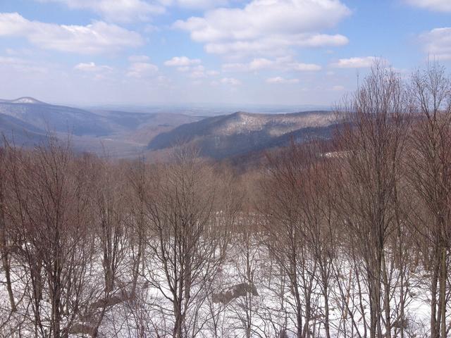 This photo shows a landscape typical of the Forested Hills and Mountains, an almost entirely forested landscape, with variable topography, and some of the highest elevations in the surroundings. Photo © kirybabe (Flickr), CC BY 2.0, Source.
Plant Lists & In-Region Search
We do not yet have data to generate plant lists for a region as fine-tuned as this one. However you can move up to the broader Central Appalachians and generate lists for that region: native plants or all plants. Or search that region's plants here:
↑References
1. Woods, A.J, Omernik, J.M., Brown, D.D. "Level III and IV Ecoregions of Delaware, Maryland, Pennsylvania, Virginia, and West Virginia", U.S. Environmental Protection Agency: National Health and Environmental Effects Research Laboratory, Corvallis, OR (1999) Web.