
Home » Regions » North America » Great Plains » West-Central Semi-Arid Prairies » Nebraska Sand Hills
Nebraska Sand Hills
Last updated: December 11th, 2025
Page contents
To check where a specific point lies, you can look it up in our Ecoregion Locator.
↑Map Legend & Subregion List
This list will help you navigate the regions in case you have problems with viewing or clicking the interactive map above.
| Name | † | Color on Map | EPA Code‡ |
| Sand Hills | ○ | 44a | |
| Alkaline Lakes Area | ○ | 44b | |
| Wet Meadow and Marsh Plain | ○ | 44c | |
| Lakes Area | ○ | 44d |
† Status: ✓ = Complete ○ = Needs Image … = Incomplete ∅ = Stub Only
‡ This code refers to the US EPA's Level 4 ecoregion codes for the continental U.S., see here.
↑Progress
Partially Complete | With Images | Complete w/ Images |
Get involved! You can help our ecoregion articles progress faster. Help us find photos of these regions. Contact us if you have any additions or corrections to any of these articles. You can also donate to support our ongoing work.
↑About the Nebraska Sand Hills
The Nebraska Sand Hills, often referred to just as the sandhills, are a region mostly located in north-central to northwestern Nebraska, and extending just barely into South Dakota. This region is both distinct from its surroundings and relatively homogeneous throughout, and represents one of the largest regions of grass-stabilized sand dunes anywhere in the world, and the largest in North America. The sand hills are formed from glacial sediment originating in the Rocky Mountains to the west.The climate is transitional between the humid end of a dry, mid-latitude steppe climate in the west, and the dry end of a humid continental climate in the east. Summers are hot and winters are cold. Precipitation is seasonal, peaking in May to June, preceding the hottest part of summer which is slightly drier, and winter being even drier. Daily and weekly weather can be unpredictable, and unusual hot, cold, wet, or dry spells can occur at any time of year. Although precipitation increases to the east, temperatures are relatively constant, reflecting two competing tendencies that balance each other out: the west of this region is significantly higher in elevation, and higher elevation regions are usually both colder and wetter, but the polar air masses bringing cold air into the center of the continent usually arrive farther east.
The terrain mostly consists of irregular sand dunes, which are steep in places and gently rolling in others. There are some gently-sloping valleys along major rivers. The landscape is underlain by sandstone and conglomerate, but in most places these rocks are buried under deep sands, with some areas of finer-textured, wind-deposited loess. Glaciation disrupted the drainage, and the arid climate and deep sands have given little opportunity for a drainage network to develop, so this region has one of the most disrupted drainage patterns anywhere on the continent. Because of the high permeability of surface soils, most rainfall quickly percolates to the water table. The disrupted drainage has led there to be a large number of lakes and wetlands, although the low rainfall and high evaporation makes most of these lakes and wetlands seasonal. Although there are a few of rivers and larger streams, there is a conspicuous lack of small streams and there are large swaths with a complete absence of moving water. The quick percolation to the water table, lack of drainage, and large size of the region combine to form one of the world's largest aquifers, the Ogallala Aquifer, centered around this region, but also extending somewhat beyond it.
Surface soils are mostly either entisols, formed where conditions are too dry for much soil development to occur, or mollisols, formed under the richer grassland sites. The soils here are largely unsuitable for Western agriculture.
Excepting riparian areas in the north and east, this region is treeless. Most of the region is covered in grasslands, with a mix of species characteristic of tallgrass, mixed-grass, and shortgrass prairie. Dominant species include little bluestem (Schizachyrium scoparium), sand bluestem (Andropogon hallii), prairie sandreed (Calamovilfa longifolia), needle-and-thread grass (Hesperostipa comata), sand lovegrass (Eragrostis trichodes), blue grama (Bouteloua gracilis), and hairy grama (Bouteloua hirsuta). Some areas, more common in the west, of alkaline wetlands feature alkali sacaton (Sporobolus airoides), cosmopolitan bulrush (Bolboschoenus maritimus), and cosmopolitan bulrush (Bolboschoenus maritimus). Because this region was unsuitable for agriculture, most of it was never tilled, and the vegetation here has some of the least-disturbed prairie remnants anywhere in the Great Plains. Owing in part to the low population and lack of agriculture, this region also has one of the lowest rates of invasive species anywhere on the continent.
Land utilization here is sparser than in surrounding regions. This region is mostly devoid of cropland, although there are a few isolated areas of irrigated cropland in valleys, producing corn or hay. Most of the region is occupied by large-scale ranches. The population is low. The largest settlement here is Valentine, with a population well under 3,000, with the next-largest being Ainsworth, Mullen, and Thedford, all in Nebraska.
The east of this region is bordered to the north by the more intensively-farmed Northwestern Glaciated Plains. Most of the rest of the region is bordered to the north by the unglaciated, and more sparsely-farmed Northwestern Great Plains. The west of the region is surrounded to the north, west, and south by the High Plains, and the rest of the region is bordered to the south by the Central Great Plains. The east of the region also has a small border with the more humid, agriculturally-intensive Western Corn Belt Plains.
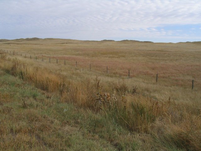 This landscape shows the Alkaline Lakes portion of the Nebraska Sandhills, near its western end. The landscape is irregular, with some steeper hills or dunes in the background, but flatter in the foreground. The single isolated fence shows that this region is utilized, albeit sparsely, for livestock grazing. Photo © Ken Lund (Flickr), CC BY-SA 2.0, Source.