
Home » Regions » North America » Great Plains » West-Central Semi-Arid Prairies » Northwestern Great Plains
Northwestern Great Plains
Last updated: December 8th, 2025
Page contents
To check where a specific point lies, you can look it up in our Ecoregion Locator.
↑Map Legend & Subregion List
This list will help you navigate the regions in case you have problems with viewing or clicking the interactive map above.
† Status: ✓ = Complete ○ = Needs Image … = Incomplete ∅ = Stub Only
‡ This code refers to the US EPA's Level 4 ecoregion codes for the continental U.S., see here.
↑Progress
Partially Complete | With Images | Complete w/ Images |
Get involved! You can help our ecoregion articles progress faster. Help us find photos of these regions. Contact us if you have any additions or corrections to any of these articles. You can also donate to support our ongoing work.
↑About the Northwestern Great Plains
The Northwestern Great Plains are a region covering much of the central to southeastern portions of Montana, southwestern North Dakota, northeastern Wyoming, and western South Dakota, extending slightly into northern Nebraska. This region corresponds roughly to the southernmost parts of the Missouri Plateau or Missouri Coteau, which escaped glaciation. Although this region is contiguous, it surround several isolated portions of the Middle Rockies, including the Black Hills in the east, and a few smaller, isolated mountains in the west.The climate here is a dry mid-latitude steppe climate, also called a cold semi-arid climate, with continental influence that is stronger in the east. Relative to areas to the east and north, this region is slightly drier and warmer. Precipitation is seasonal, with dry winters, and a rainy season peaking in May in most of the region, but in June in the easternmost end. Late summer brings hotter temperatures and slightly less rain. Rainfall can be highly variable from one year to the next, and there can be long spells of unusually wet or dry weather. Precipitation decreases moving westward. Although the region slopes upwards to the west, the decrease in rainfall moving west is great enough to offset the usual increase in rainfall with elevation. The region also tends to be warmer in the west, particularly in winter, reflecting a greater distance from the cold polar air masses that tend to push farther southward in the interior of the continent.
The terrain is irregular, ranging from rolling plains to rugged badlands, with some isolated buttes throughout. This region was never glaciated and thus has a well-developed drainage network, with uplands having a regular pattern of dissection, with regularly-spaced, V-shaped valleys. Most of the streams here are ephemeral or intermittent, but there are a few perennial rivers originating in the mountains to the west and flowing through this region. Most of the region drains into the Missouri River, which flows in and out of this region as it cuts across the glacial limit. There are few natural lakes or ponds, but there are many small artificially-constructed impoundments to create small, temporary reservoirs for irrigation, and some large reservoirs along the Missouri river, including Lake Oahe and Fort Peck Lake which are located entirely within this region, and Lake Sakakawea which is partly located within this region.
Most of this region is underlain by sandstone or shale; the shale is easily eroded whereas the sandstone is more erosion-resistant, and the topography is mostly explained by the relative distribution of these two substrates. Surface soils are highly diverse, including soils of the entisol, mollisol, aridisol, and inceptisol orders. Soil formation here is limited both by the cold temperatures and lack of moisture. The mollisols are the richest soils, generally forming under grasslands in low, flat areas that capture more moisture and nutrients washed downstream. Entisols, the poorest soils found here, formed mostly on steeper upland sites where the dry climate and lack of accumulation of organic matter provided little opportunity to weather the parent material before erosion exposed more surface materials. Aridisols represent the older, more well-developed soils formed on more stable upland sites, usually forming under dry scrublands. Inceptisols form where erosion exposes underlying material but the soil is higher in organic matter. Of these soils only the mollisols and inceptisols are suitable for agriculture, but the unpredictably, dry climate here makes farming precarious; mismanagement can quickly lead to loss or degradation of soils on cropland.
This region was originally covered mostly covered in grasslands transitional between mixed-grass prairie and shortgrass prairie. Dominant grasses included blue grama (Bouteloua gracilis), western wheatgrass (Pascopyrum smithii), green needlegrass (Nassella viridula), prairie sandreed (Calamovilfa longifolia), and buffalo grass (Bouteloua dactyloides). There is some area of sagebrush, with big sagebrush (Artemisia tridentata) ssp. wyomingensis, rubber rabbitbrush (Ericameria nauseosa), and sand sagebrush (Artemisia filifolia). There are some areas with scattered ponderosa pine (Pinus ponderosa) and rocky mountain juniper (Juniperus scopulorum). Some of the original grasslands remain in rangeland, especially where the topography is rugged, protecting some less-accessible areas. Flatter areas are more likely to have had the original vegetation disrupted or removed entirely.
The dominant land use here is as rangeland for livestock grazing, mostly cattle and sheep. There is relatively little cropland here, owing mainly to the lack of reliable water sources, driven both by the unpredictably dry climate and the lack of sources of irrigation water. The main crops here are wheat, alfalfa, and barley. There is also a small amount of coal mining. The largest city in this region is Billings, MT, which has been growing rapidly in recent years. The largest city and only settlement of appreciable size in the ND section is Dickinson. In South Dakota, Rapid City is the largest city, although it lies at the border of this region and the Black Hills. The largest city in the Wyoming portion is Casper, at the southern border of this region. Unlike regions to the north and east, most of the land here has only a sparse road network.
The Standing Rock Reservation and Cheyenne River Reservations are located entirely within this region, in South Dakota. During the construction of the Oahe Dam, Native Americans from both reservations were forcibly relocated; the dam flooded over 200,000 acres of the these reservations. More recently, this region has become a point of contention in the fight over the Dakota Access Pipeline. Poverty has been a major problem for the displaced people from these reservations, as their traditional way of life was disrupted. In Montana, the Crow Reservation and Northern Cheyenne Reservation are located in this region.
There is some public protected land here, including Thunder Basin National Grassland in Wyoming, Ogala National Grassland in Nebraska, Badlands National Park in South Dakota, the Dakota Prairie Grasslands in North Dakota, and the Upper Missouri River Breaks National Monument in Montana. These lands, although representing relatively large, contiguous portions of protected land, represent a small total portion of this region; most of the region has little protected land. There is also the Charles M. Russell National Wildlife Refuge, formerly called the Fort Peck Game Range; however, this region, although managed for wildlife preservation, surrounds an artificial reservoir, and management priority is given to the Army Corps of Engineers over the Fish and Wildlife Service, and there have been a number of court battles which during certain periods gave priority to ranching over wildlilfe protection.
This region is bordered to the north and east by the Northwestern Glaciated Plains, which tends to be lower and slightly flatter, and have a disrupted drainage network with more lakes, ponds, and wetlands, and which has a greater portion of cropland. The southeastern portion of this region is bordered to the south by the Nebraska Sand Hills. West of that there is a border with the High Plains, and west of that, a small border with the Southern Rockies. Between the mountains, this region opens up to the Wyoming Basin, a region which is much drier than this one due to rain shadow from surrounding mountains. There are also numerous borders with the Middle Rockies, and several isolated portions of that region are surrounded by this one.
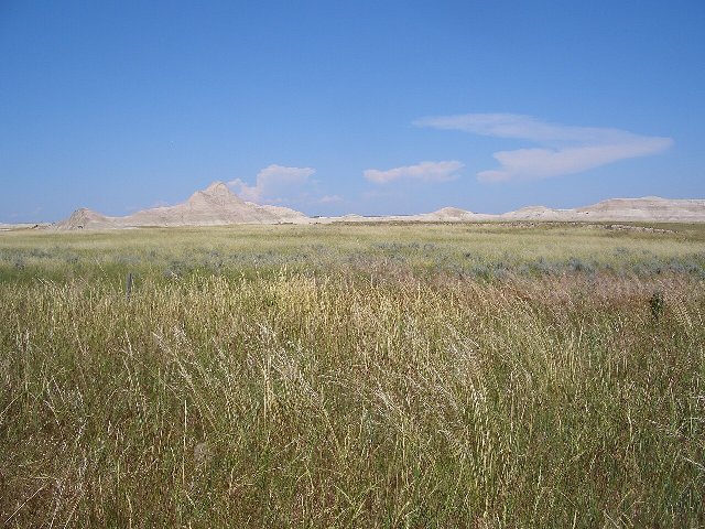 This photo shows the Oglala National Grassland in Nebraska, which is near the southeastern end of the Northwestern Great Plains. The irregular terrain, only gently sloping in the foreground, but with irregular badlands in the distance, is typical of this region. Grasslands cover the moister lower areas, but steeper uplands are more barren. Photo © Brian Kell (Wikipedia Bkell), Public Domain, Source.