
Home » Regions » North America » Eastern Temperate Forests » Mixed Wood Plains » Acadian Plains and Hills » Aroostook Hills
Aroostook Hills
Last updated: July 22nd, 2020
Page contents
↑About the Aroostook Hills
The Aroostook Hills are a region in northeastern Maine, extending into New Brunswick, that represent a transition between more mountainous regions to the west, and flatter areas to the east. The region is mostly north-south oriented, and is broadest at its southern end.This region consists of plains and hills, with elevations mostly ranging from 600 to 1,000 feet, although some isolated peaks stretch much higher, the highest being Mt. Chase (2,440 ft.) There are some lakes and many smaller ponds, bogs, and other wetlands. The region is mostly covered in loamy glacial till, with some sandy-loamy till; the till is thin over parts of the region. The bedrock is diverse, consisting mostly of weakly metamorphosed sedimentary rocks of various types, with some metavolcanic rock and some igneous intrusions. Most of the area has acidic, nutrient-poor soils, although calcareous rocks occur through parts of the region and produce less-acidic substrates.
This region originally supported a variety of forest types. Spruce-fir-broom moss forest featured a mix of red spruce (Picea rubens), balsam fir (Abies balsamea), and eastern hemlock (Tsuga canadensis), beech-birch-maple forest featured American beech (Fagus grandifolia), yellow birch (Betula alleghaniensis), and sugar maple (Acer saccharum) as dominants, with some eastern hemlock, red maple (Acer rubrum), white ash (Fraxinus americana), and paper birch (Betula papyrifera). Spruce-northern hardwood forest consisted of red spruce, yellow birch, balsam fir, and some eastern white pine (Pinus strobus). White pine-mixed conifer forest featured eastern white pine, red spruce, red pine (Pinus resinosa), eastern hemlock, and red maple. Flat, wet areas supported spruce-fir-cinnamon fern forests, with red and black spruce (Picea mariana), red maple, and balsam fir, and cinnamon fern (Osmunda cinnamomea) in the understory. Poorly-drained sites also supported northern white cedar swamps with northern white-cedar (Thuja occidentalis), black spruce, and various herbs and shrubs. Floodplains supported silver maple (Acer saccharinum) in the far southwest, but over most of the region, balsam poplar floodplain forests, with balsam poplar (Populus balsamifera), american elm (Ulmus americana), black ash (Fraxinus nigra), green ash (Fraxinus pennsylvanica), and balsam fir.
This region is heavily utilized for forestry, including for pulp and paper production. Although significant forest cover remains, much of the region consists of recently-cleared land and forests early in the process of regeneration. There is also a small amount of pasture and cropland, mostly concentrated in the north of this region, along the St. John river, from Fort Kent ME and Clair, NB, eastward. In addition to these uses, the land here is utilized for hunting, fishing, recreation, and wildlife habitat.
Over most of its length, this region is bordered to the east by the lower, flatter Aroostook Lowlands, and to the west by the more rugged, upland St. John Uplands. In the south, it is bordered to the southwest by the even higher-elevation Quebec/New England Boundary Mountains, to the south, in a small border with the topographically-similar Central Foothills, and to the southeast by the lower, flatter Eastern Maine-Southern New Brunswick Plains.
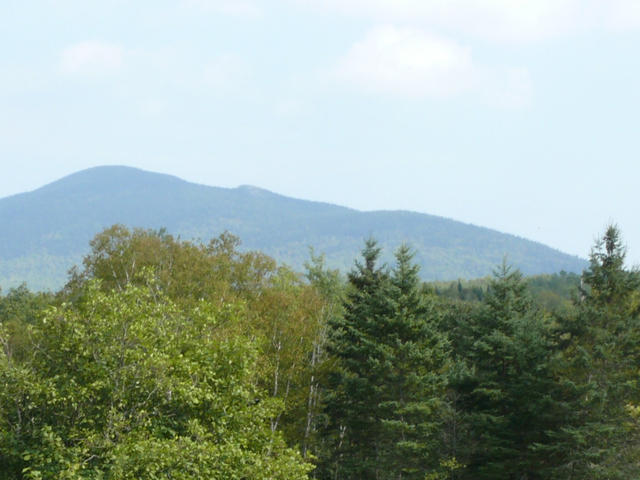 This photo shows a more typical landscape of the Aroostook Hills in the foreground, with a view of Mt. Chase, an atypical high peak in this region, in the background. This is a crop of a photo by Maineshepp (Wikimedia Commons), CC BY-SA 3.0, Source.
Plant Lists & In-Region Search
We do not yet have data to generate plant lists for a region as fine-tuned as this one. However you can move up to the broader Acadian Plains and Hills and generate lists for that region: native plants or all plants. Or search that region's plants here:
↑References
1. Griffith, G.E., Omernik, J.M., Bryce, S.A., Royte, J., Hoar, W.D., Homer, J.W., Keirstead, D., Metzler, K.J., and Hellyer, G. "Ecoregions of New England (Poster)", U.S. Geological Survey (2009) Web.