
Home » Regions » North America » Northwestern Forested Mountains » Western Cordillera » Northern Rockies
Northern Rockies
Last updated: July 6th, 2023
To check where a specific point lies, you can look it up in our Ecoregion Locator.
↑Map Legend & Subregion List
This list will help you navigate the regions in case you have problems with viewing or clicking the interactive map above.
† Status: ✓ = Complete ○ = Needs Image … = Incomplete ∅ = Stub Only
‡ This code refers to the US EPA's Level 4 ecoregion codes for the continental U.S., see here.
↑Progress
Partially Complete | With Images | Complete w/ Images |
Get involved! You can help our ecoregion articles progress faster. Help us find photos of these regions. Contact us if you have any additions or corrections to any of these articles. You can also donate to support our ongoing work.
↑About the Northern Rockies
The Northern Rockies, referred to in some documents as the Columbia Mountains/Northern Rockies, is a region of mountains in the interior of British Columbia, northeastern Washington State, northern Idaho, and northwest Montana. In British Columbia this region is referred to colloquially as the "Interior Wet Belt". It encompasses a number of distinct named mountain ranges, including the Cariboo mountains in the north, the Columbia Mountains, Selkirk Mountains, and what is referred to as the Northern Rockies in the US.The climate here varies considerably by elevation and location. Low elevations share aspects of a humid continental climate and an oceanic climate, but more severe and variable than a true oceanic climate. High elevations grade into subartic climates, with glaciers at the highest elevation in the north of the region. The southwesternmost portion of this region is more arid and slightly resembles a Mediterranean climate. Weather is driven largely by the contrast between moist, moderate air from the Pacific, and drier continental air, with air masses from different origins tending to predominate at different times of year. There can be considerable day-to-day variation in weather too.
Precipitation here is weakly seasonal, but the pattern of seasonality changes considerably throughout the region. The entire region has wet winters (Nov-Jan), with frequent, heavy snowfalls. The southeast part of the region has a unimodal pattern of seasonal precipitation in which summers (July-August) are driest. However, most of the region follows a weak and asymmetric bimodal pattern, with drier late winter and early spring (Feb-Apr) followed by a second wet season in late spring and early summer, then followed by a drier late summer and fall. The exact timing and duration of these other wet and dry seasons vary regionally. There is some rain year-round. Spring tends to arrive earlier here than is typical for such a northerly, high-elevation region. Precipitation tends to be high, but varies considerably by elevation, and is lowest in the southwest.
The terrain here is rugged, with mountains alternating with deep, narrow valleys. The terrain tends to become steepest towards the north and east of this region. The geology is diverse, and encompasses a variety of rocks of different ages and compositions, including mostly igneous and metamorphic rocks, with some folded sedimentary layers. Soils here are diverse, with a number of well-developed, richer soils especially in the valleys, and a number of rocky, poorly-developed soils on steeper, colder upper slopes, as well as andisols, relatively fertile soils formed on volcanic ash. Because of the steep nature of this region, as well as recent glaciation, most of the surface soils formed either on colluvium or on glacial moraines, rather than directly from the underlying bedrock.
This region is mostly covered in coniferous forests, with a composition intermediate between that of the West Coast temperate rainforests and the rest of the Rocky Mountains. Key species here include western hemlock (Tsuga heterophylla), western redcedar (Thuja plicata), mountain hemlock (Tsuga mertensiana), grand fir (Abies grandis), douglas fir (Pseudotsuga menziesii), subalpine fir (Abies lasiocarpa), engelmann spruce (Picea engelmannii), western larch (Larix occidentalis), western white pine (Pinus monticola), lodgepole pine (Pinus contorta), and ponderosa pine (Pinus ponderosa). Higher elevations open into alpine meadows and then glaciers.
This region is heavily utilized relative to how steep and mountainous it is, in part because it is easily accessible. There are multiple major roads through the region, and even before these were built, this region was more accessible due to the Columbia River, which was a major thoroughfare in earlier times. Land use here includes forestry, tourism and recreation, mining, and hydroelectric power and water reservoirs. There is also some localized agriculture and livestock grazing. There are some large areas of protected public land, and there are also some lands belonging to the indigenous people of this region. The only larger city here is Spokane, WA, at the very southwestern edge of the region. After this the next largest city is Nelson, BC, and other important communities, all well under 10,000 people in population, include Revelstoke, BC, Creston, BC, Polson, MT, Colville, WA, Sandpoint, ID, and Bonners Ferry, ID; most of these communities fluctuate in size seasonally due to tourism.
This region is bordered to the east by the Canadian Rockies, a geologically similar region that tends to be drier due to rain shadow. At its very north end, it is bordered to the north by the Skeena-Omineca-Central Canadian Rocky Mountains, and along a short length, to the west by the Chilcotin Ranges and Fraser Plateau, a flatter region. In the middle of this region, it is bordered to the west by the somwehat flatter, more arid Thompson-Okanagan Plateau. South of that, it is bordeerd to the west by the much flatter, much more arid Columbia Plateau. At its southern end, it is bordered to the south by the Idaho Batholith and also has a small border to the southeast with the Middle Rockies.
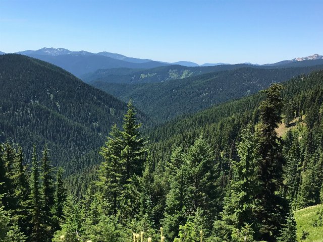 This photo shows forested mountains in the Idaho Panhandle, in the southernmost regions of the Northern Rockies; although the terrain looks steep this is actually some of the gentler terrain in the region and there are much steeper slopes and higher mountains farther north in Canada. Crop of a public domain photo from the US Forest Service - Northern Region, Source.
Plant Lists & In-Region Search
List Native Plants - List All Plants
Warning! This region extends outside the lower 48 US. We have only completed range maps for all plants in the lower 48 US; these lists and searches may thus have omissions for species which only occur in the portion of this region outside the lower 48 US.