
Home » Regions » North America » North American Deserts » Cold Deserts
Cold Deserts
Last updated: September 13th, 2023
To check where a specific point lies, you can look it up in our Ecoregion Locator.
↑Map Legend & Subregion List
This list will help you navigate the regions in case you have problems with viewing or clicking the interactive map above.
| Name | † | Color on Map | CEC Code‡ |
| Columbia Plateau | ✓ | 10.1.2 | |
| Snake River Plain | ✓ | 10.1.8 | |
| Central Basin and Range | ✓ | 10.1.5 | |
| Wyoming Basin | ✓ | 10.1.4 | |
| Colorado Plateaus | ✓ | 10.1.6 | |
| Arizona/New Mexico Plateau | ✓ | 10.1.7 | |
| Northern Basin and Range | ✓ | 10.1.3 | |
| Thompson-Okanagan Plateau | ✓ | 10.1.1 |
† Status: ✓ = Complete ○ = Needs Image … = Incomplete ∅ = Stub Only
‡ This code refers to the CEC's Level 3 ecoregion codes for North America, see here.
↑Progress
Partially Complete | With Images | Complete w/ Images |
Get involved! You can help our ecoregion articles progress faster. Contact us if you have any additions or corrections to any of these articles. You can also donate to support our ongoing work.
↑About the Cold Deserts
The Cold Deserts are a a collection of deserts in western North America characterized by colder temperatures. They include both more northerly desert regions, north into British Columbia, and some more southerly ones at higher altitudes, south into the plateaus of Arizona and New Mexico. Most of Nevada and Utah are located in this region, as well as a large portion of Wyoming, eastern Oregon and Washington, southern Idaho, and the westernmost portion of Colorado. The largest contiguous stretch of cold desert is located mostly in Nevada but extends well into western Utah, southern Idaho, and southeastern Oregon.These deserts exist largely because of rain shadow produced by mountain ranges; coastal ranges extract moisture from weather systems moving east from the Pacific ocean through the mechanism of orographic lift. When the air reaches lower-altitude regions again, little moisture is left, and deserts result. These regions are also separated by mountains from moister regions to the east, although these ranges play less of a role due to the west-east motion of most weather systems at these latitudes. Mountains also shield this region from the effect of the North American monsoon, preventing most of the summer moisture from reaching these interior areas.
The topography of these regions consist of plains or tablelands, often separated by mountain ranges. Rainfall is low, up to 10 inches (25 cm) and sometimes much lower. Soils are dry and mostly alkaline due to retaining a high calcium content. Temperature swings between day and night can be extreme, and freezing temperatures are common in winter. However, due to mountains hindering the movement of large land masses, continental climate influences are less here than in the Great Plains to the east, and temperatures here tend to be more predictable from day to day than they are on the Great Plains.
Because of the low rainfall, most streams here are ephemeral, but there are also numerous large rivers, originating in higher-rainfall regions, that flow through this region. Most of the region drains west to the Pacific ocean, but parts of it drain east, and parts are endorheic, draining internally. Where there is endorheic region, there are often seasonal lakes or playas, or in drier areas, permanent salt flats.
The vegetation ranges from scrubland to grassland, both of which are low and sparse in most places; some parts of this region have large expanses devoid of vegetation, such as salt flats. Plants here need to be adapted both to drought and to winter cold. Owing to the colder tmeperatures here, cacti are less common and dominant here, unlike the warm deserts farther south.
These regions are largely surrounded by other mountainous ecoregions: in the north, the Western Cordillera, and at the southernmost part of this region, the Upper Gila Mountains. These transitions are abrupt and happen with changes in altitude. In the southwest of this region (Nevada, eastern California, and northwest Arizona), where this region is not bordered by mountains, it transitions gradually into the Warm Deserts. In Wyoming, to the northeast, it gradually transitions to the West-Central Semi-Arid Prairies, part of the Great Plains.
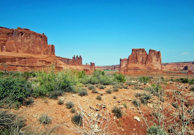 This photo shows a landscape at Arches National Park in Utah, one of the more charismatic locations within the Cold Deserts of North America. The low, sparse scrub growth with lots of open space between plants is a common type of vegetation cover in this region; other areas have more grasses. Photo © Don Graham, CC BY-SA 2.0, Source.
Plant Lists & In-Region Search
List Native Plants - List All Plants
Warning! This region extends outside the lower 48 US. We have only completed range maps for all plants in the lower 48 US; these lists and searches may thus have omissions for species which only occur in the portion of this region outside the lower 48 US.