
Home » Regions » North America » Marine West Coast Forest » Willamette Valley
Willamette Valley
Last updated: July 24th, 2023
To check where a specific point lies, you can look it up in our Ecoregion Locator.
↑Map Legend & Subregion List
This list will help you navigate the regions in case you have problems with viewing or clicking the interactive map above.
| Name | † | Color on Map | EPA Code‡ |
| Portland/Vancouver Basin | ○ | 3a | |
| Willamette River and Tributaries Gallery Forest | ○ | 3b | |
| Prairie Terraces | ○ | 3c | |
| Valley Foothills | ○ | 3d |
† Status: ✓ = Complete ○ = Needs Image … = Incomplete ∅ = Stub Only
‡ This code refers to the US EPA's Level 4 ecoregion codes for the continental U.S., see here.
↑Progress
Partially Complete | With Images | Complete w/ Images |
Get involved! You can help our ecoregion articles progress faster. Help us find photos of these regions. Contact us if you have any additions or corrections to any of these articles. You can also donate to support our ongoing work.
↑About the Willamette Valley
The Willamette Valley is a north-south valley located mostly in northwestern Oregon and extending barely into Washington state. The Willamette river is the central feature of this valley, which is surrounded by mountains to the west, east, and south. At the north of this region, it flows into the Columbia river, which for the most part represents the northern border of this region, although we define the region so that it includes a small, ecologically-similar area on the north bank of the Columbia river, around Vancouver, Washington.The climate here is transitional between a marine west coast climate and Mediterranean climate. Winters are cool and wet and summers warm and dry, with a relatively smooth transition through spring and autumn seasons with more average temperatures and rainfall. Overall, temperatures are moderate relative to other climates of this high a latitude, but relative to the Puget Lowlands to the north, and especially to the broader Marine West Coast Forest region, this area is drier and has slightly more variable weather, including greater potential for heat waves in summer. Severe weather, such as tornadoes and thunderstorms, is rare, and snowfall tends to be ephemeral.
Most of this region consists of broad, flat bottomlands, terraces, and rolling hills. Elevations range from 20ft (6m) along the Columbia river to about 1970ft (600m) around the edges of this region. The region is mostly underlain by volcanic basalt and marine sandstone, but in most places the bedrock is deeply covered in alluvial deposits, colluvium, and deposits that formed under glacial lake Allison around 15,000 years ago. This lake formed when glacial melt was temporarily blocked by a narrow strait near where Kalama, Washington is now located. As the water drained, it left fine sediments in this area. Soils here tend to be diverse in texture, but tend to be nutrient-rich and highly fertile, unlike most of the soils in the broader surroundings. The flatter terrain and richer soils explain why this region has become a center for both agriculture and urban population.
Several large rivers and numerous streams flow through this area, most of which originate outside the region, in mountains where rainfall is higher. Some of the streams originate in the hillier areas around the edges of this region. There are numerous ponds and seasonal wetlands.
Before European colonization, this area was covered by a mix of vegetation types. Like the areas to the north, there was significant coniferous forest, wetlands, and deciduous forests in riparian areas, but there were also more open habitats including prairies and oak savannas. Although not contiguous with either, this region can be seen as intermediate between the grassland-dominated Central California Valley farther south, and the forest-dominated Puget Lowlands / Georgia Depression farther north. Dominant trees here include Oregon white oak (Quercus garryana), Douglas-fir (Pseudotsuga menziesii), pacific madrone (Arbutus menziesii), and ponderosa pine (Pinus ponderosa). Bottomlands featured black cottonwood (Populus tristis), Oregon ash (Fraxinus latifolia), bigleaf maple (Acer macrophyllum), Douglas-fir, western redcedar (Thuja plicata), and a variety of shrubs.
This area is heavily utilized for cropland, industry, and urban development. Almost no prairies remain. The bulk of Oregon's population lives here, mostly in the metro area of Portland, with some in the Salem metro area as well, and the population, and residential land use, has been increasing significantly in recent years. This is one of the primary agricultural areas in Oregon, producing vegetables, fruits, nuts, nursery products, and grass seed. The foothills support vineyard, Christmas tree farms, and there is some sheep and cattle grazing. Humans have altered the hydrology somewhat, creating a few large reservoirs maintained by dams.
This region is bordered to the west by the Coast Range, a higher-elevation, more rugged region with greater rainfall and a more consistently-humid climate. It is bordered to the east and north by the Cascades, also a more rugged region, which has higher rainfall than this region but less so than the Coast Range, and has a more variable climate as well. To the south this region is bordered by the northernmost end of the Klamath Mountains/California High North Coast Range, yet another mountain range that, near the border with this region, tends to be slightly lower and less rugged than the ranges to the east and west, although farther south they become much more rugged.
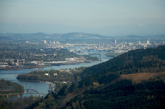 This photo, showing Portland in the distance, shows one of the more urbanized parts of the Willamette Valley; the river is central, with flatter areas along it, but farther from the river the terrain is quite hilly. Photo © Sam Beebe, CC BY 2.0, Source.
Plant Lists & In-Region Search
↑References
1. Wiken, E., Griffith, G. "North American Terrestrial Ecoregions - Level III", Commission for Environmental Cooperation, (2011) Web.