
Home » Regions » North America » Northwestern Forested Mountains » Western Cordillera » Cascades
Cascades
Last updated: June 20th, 2022
To check where a specific point lies, you can look it up in our Ecoregion Locator.
↑Map Legend & Subregion List
This list will help you navigate the regions in case you have problems with viewing or clicking the interactive map above.
† Status: ✓ = Complete ○ = Needs Image … = Incomplete ∅ = Stub Only
‡ This code refers to the US EPA's Level 4 ecoregion codes for the continental U.S., see here.
↑Progress
Partially Complete | With Images | Complete w/ Images |
Get involved! You can help our ecoregion articles progress faster. Help us find photos of these regions. Contact us if you have any additions or corrections to any of these articles. You can also donate to support our ongoing work.
↑About the Cascades
The Cascades are a mountainous region extending from Washington State through Oregon and into northern California. This region does not correspond exactly to the Cascade Range; it covers roughly the southernmost two-thirds of the region, and does not include the easternmost slopes. This categorization allows the grouping of climatically and ecologically coherent areas.This region has been recently influenced by glaciation, and is also volcanically active, including both active and dormant volcanoes. Elevations reach over 14,000 feet (4250m). The climate is intermediate between a temperate continental climate and a Mediterranean climate. It tends to have warm, dry summers and cool but not cold, very wet winters. Rainfall totals are much higher than the lower-lying valleys to the west of this region, but lower than in the coastal mountain ranges when comparing areas of similar elevation. These precipitation patterns are the result of orographic lift: the coastal mountains extract some of the moisture from the air as weather systems move west-to-east. There are numerous natural lakes throughout, reflecting the combination of high rainfall with recent glaciation disrupting the drainage network. Streams are numerous and there are both perennial and seasonal streams, which tend to have good water quality.
This area is mostly covered in coniferous forest, with a few meadows and rocky, exposed areas at the highest elevations. Dominant tree species include Douglas-fir (Pseudotsuga menziesii), western hemlock (Tsuga heterophylla), western redcedar (Thuja plicata), bigleaf maple (Acer macrophyllum), and red alder (Alnus rubra) at low elevations in the north, and at higher elevations, pacific silver fir (Abies amabilis), mountain hemlock (Tsuga mertensiana), subalpine fir (Abies lasiocarpa), noble fir (Abies procera), and lodgepole pine (Pinus contorta). Farther south, dominant trees also include incense cedar (Calocedrus decurrens), white fir (Abies concolor), and shasta red fir (Abies ×shastensis). The highest elevations extend past the tree line and are covered in subalpine meadows, with barren rocky alpine zones beyond that, and some of the highest zones featuring glaciers and snowfields.
The forests here are heavily logged and intensively managed for forestry. This area is sparsely populated, and the population is almost exclusively located in a small number of low, flat regions along rivers and streams. The narrow region where the Columbia river cuts through this region has a few towns, the largest of which are Stevenson, WA and Cascade Locks, OR. Outside of this area the largest settlement is Oakridge, OR, located in a small flat area at the confluence of several forks of the Willamette River. This region is also used for the water supplies both of urban areas, mostly to the west of the region, and agriculture, in lower, flatter, drier regions adjacent to this one. To this end, many of the rivers, mostly at lower elevations, have been dammed, creating large reservoirs. There are also large areas of protected public land here, including both national forest and national parks, here.
Over its entire length, this region is bordered to the east by the Eastern Cascades Slopes and Foothills, a region that is part of the same geologic formation, but which is treated as a separate ecoregion due to being in the rain shadow of this region; it has lower elevations, a more arid climate, and sparser forests. To the north, this region is bordered by the North Cascades, also part of the same geologic formation, but slightly colder. At the south of this region, it is bordered to the southwest by the Klamath Mountains/California High North Coast Range, another mountainous region with slightly less seasonal variability in climate. Over most of this region's length, it is bordered to the west by the Willamette Valley, a lower-elevation region with a slightly drier, but less variable climate, that is heavily populated and also heavily utilized for agriculture. At the north of this region, it is bordered to the west by the Puget Lowlands / Georgia Depression, a similar region that is lower elevation, more populous, and with a less variable climate, but slightly cooler and moister than areas to the south. In the north, this region has an irregular shape and there are a few places where it is partly surrounded by the Coast Range, a coastal mountain range with a strongly ocean-moderated climate. Most of these borders represent gradual transitions where arbitrary cutoffs have been made.
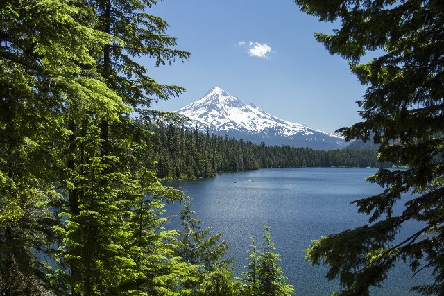 This landscape shows a lake surrounded by coniferous forest; Mount Hood rises in the background, covered in glaciers and snowfields. This photo captures the mid-to-high elevations in the Cascades. Public Domain photo by Bonnie Moreland, Source.
Plant Lists & In-Region Search
↑References
1. Wiken, E., Griffith, G. "North American Terrestrial Ecoregions - Level III", Commission for Environmental Cooperation, (2011) Web.