
Home » Regions » North America » Northern Forests » Mixed Wood Shield » Northern Lakes and Forests » Newaygo Barrens
Newaygo Barrens
Last updated: August 17th, 2020
Page contents
↑About the Newaygo Barrens
The Newaygo Barrens are a region of in the interior of the lower peninsula of Michigan, characterized by sandy soils and a cold climate with significant lake-effect snow and some moderation of temperature from the lake. This region is fire-prone and the natural ecosystems here are fire-adapted.This region is mostly flat but with locally somewhat irregular topography. Much of the region consisting of flat or pitted outwash plains and channels, interspersed with some hillier areas of glacial moraines. Small lakes are irregularly distributed througout the region. The soils throughout this region are mostly sandy and moderately-to-execessively well-drained. The region has a cold humid continental climate with some moderation of temperature from the lake, and significant lake-effect snow; these effects are strongest in the west. Cold air drainage off the Mio Plateau to the east increases the risk of late spring frost.
This area was originally covered by tallgrass prairie and savanna with oak and eastern white pine (Pinus strobus); these habitats were perpetuated by frequent low-intensity ground fires. There were also jack pine (Pinus banksiana) and northern pin oak (Quercus ellipsoidalis) on the even drier soils of glacial outwash plains; these communities were maintained by higher-intensity fires. Areas closer to Lake Michigan, protected from fire by the more humid microclimate, supported American beech (Fagus grandifolia) and sugar maple (Acer saccharum). Areas with sandy loam soil supported a sligthly more diverse forest, with sugar maple, red pine (Pinus resinosa), and some white pine and jack pine. Areas with slightly poorly-drained soils supported northern white-cedar (Thuja occidentalis), balsam fir (Abies balsamea), red maple (Acer rubrum), and eastern hemlock (Tsuga canadensis).
There is some agriculture in this region, mostly pastureland, although it has declined greatly due to the soils being prone to erosion, drought, and leaching of nutrients. The area formerly produced grain, corn, and specialty crops, but there is little cropland left. There are some pine plantations. Sites with more poorly-drained soils are more likely to have been maintained as pastureland. Much of the abandoned farmland has reverted to second-growth forest of white oak (Quercus alba), black oak (Quercus velutina), and jack pine. Much of this region is protected public land, part of the Huron-Manistee National Forests.
This region is bordered to the west by the Michigan Lake Plain, which has hillier and more diverse terrain and a more moderate climate. To the south there is a small border with the Lake Michigan Moraines, and east of that, the more agriculturally-fertile Lansing Loamy Plain. To the east there is a long border with the hillier Cadillac Hummocky Moraines. The northern borders of this region are a bit less well-defined; to the northwest there is a small border with the Manistee-Leelanau Shore along the lake, and east, inland of that, with the Platte River Outwash.
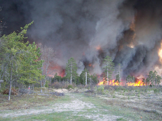 This photo shows the Meridian Fire in 2010, burning a forest of mostly jack pine, in Huron-Manistee National Forest. Sandy soils and fire-prone ecosystems dominated by jack pine are common in the Newaygo Barrens. Photo © US Forest Service, CC BY 2.0, Source.
Plant Lists & In-Region Search
We do not yet have data to generate plant lists for a region as fine-tuned as this one. However you can move up to the broader Northern Lakes and Forests and generate lists for that region: native plants or all plants. Or search that region's plants here:
↑References
1. Omernik, J.M., Bryce, S.A. "Michigan: Level III and IV Ecoregion Descriptions / Mapping Issues", US EPA (2007) Web.