
Home » Regions » North America » Eastern Temperate Forests » Mixed Wood Plains » Southern Michigan/Northern Indiana Drift Plains » Lansing Loamy Plain
Lansing Loamy Plain
Last updated: March 30th, 2021
↑About the Lansing Loamy Plain
The Lansing Loamy Plain is a large region in the interior of Michigan's lower peninsula, centered around Lansing.This region consists mostly of gently rolling ground moraines, a blanket of till deposited under a glacier. The terrain consists of hills of well-drained soils alternating with poorly-drained depressions, with the landscape cut by glacial outwash channels. The region has a humid continental climate, with little to no appreciable lake effect. The frost-free season ranges from 140-150 days, shorter than regions both to the west and east. Soils on ground moraine, making up most of the soils here, tend to be loamy and ideally suited to agriculture, whereas on terminal moraines they tend to be sandy and dry, and in the narrow outwash channels there are also poorly-drained soils.
Original cover was mostly beech-sugar maple forest, with American beech (Fagus grandifolia) and sugar maple (Acer saccharum) as dominant trees, and minor components of American basswood (Tilia americana), black maple (Acer nigrum), northern red oak (Quercus rubra), and white ash (Fraxinus americana). Black maple, although nowhere dominant, was and still is much more common here than in surrounding regions. The relatively less common terminal moraines and outwash plains, with drier, better-drained soils, supported oak-hickory forests, with northern red oak and white oak (Quercus alba) dominant. The driest sites, sandy ridges in the outwash plains, supported black oak (Quercus velutina), white oak, and pignut hickory (Carya glabra). Poorly-drained depressions and floodplains supported forests of American elm (Ulmus americana), green ash (Fraxinus pennsylvanica), silver maple (Acer saccharinum), and swamp white oak (Quercus bicolor), as well as some areas of wet prairie or wet meadows along streams. Tamarack (Larix laricina) was also found on the poorly-drained sites along outwash channels. In the northwest, eastern white pine (Pinus strobus) and eastern hemlock (Tsuga canadensis) become more common, reflecting colder temperatures. Throughtout most of these forests, windthrow was probably the most common natural disturbance.
Nearly all of this region has been cleared and converted to agriculture. Ditching and channelization to drain areas is common, and such practices have destroyed or degraded nearly all the wet prairies. Row crops including corn, soybeans, and hay are produced on the moister sites; sandier soils have been utilized for pasture, and many have been abandoned due to low productivity, and allowed to convert back to second-growth forest. The steepest sites, located on terminal moraines, are still covered in oak-hickory forest. There are small woodlots throughout, even in the more intensive agricultural areas. There is also a small amount of protected land, mostly in state game lands such as the Maple River State Game Area. The Maple River has forests along most of its length. Common hackberry (Celtis occidentalis), not initially mentioned in surveys of this area, is now found in second-growth forests on swampy ground.
This region is quite populous but the population is centered in a few urban areas, and the rest of the region is rural and sparsely-populated. It contains the metropolitan areas of Grand Rapids, Lansing, and Flint, which are, respectively, the second-, third-, and fourth-largest metro areas in Michigan. These regions all have extensive low-density suburbanization around their margins.
This region is bordered to the west by the Lake Michigan Moraines, which has a similar topography and substrates, but a more lake-influenced climate. To the south, it borders the much hillier Interlobate Dead Ice Moraines, except in two areas where it shares small borders directly with the Battle Creek/Elkhart Outwash Plain. To the northeast, it borders the much flatter Saginaw Lake Plain. To the northwest it is bordered by the Cadillac Hummocky Moraines. At the far north, there is also a small border with the Mio Plateau, and in the far west there is a small border to the north with the Newaygo Barrens.
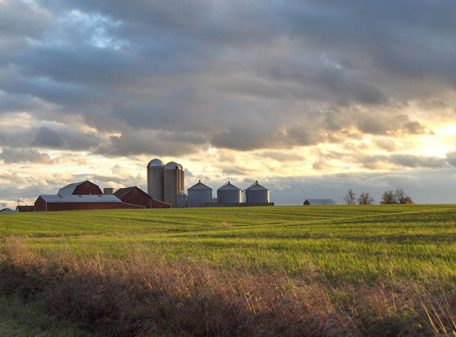 This photo shows a landscape typical of the Lansing Loamy Plain, the terrain only gently hilly and cropland dominating the land use, reflecting the fertile loamy soils through much of the area. Photo © Deb Nystrom, CC BY-SA 2.0, Source.
Plant Lists & In-Region Search
We do not yet have data to generate plant lists for a region as fine-tuned as this one. However you can move up to the broader Southern Michigan/Northern Indiana Drift Plains and generate lists for that region: native plants or all plants. Or search that region's plants here:
↑References
1. Omernik, J.M., Bryce, S.A. "Michigan: Level III and IV Ecoregion Descriptions / Mapping Issues", US EPA (2007) Web.
2. Albert, Dennis A. "Regional landscape ecosystems of Michigan, Minnesota, and Wisconsin: a working map and classification.", General Technical Report NC-178, U.S. Department of Agriculture, Forest Service, North Central Forest Experiment Station, St. Paul, MN (1995) Web.