
Home » Regions » North America » Eastern Temperate Forests » Mixed Wood Plains » Southern Michigan/Northern Indiana Drift Plains » Lake Michigan Moraines
Lake Michigan Moraines
Last updated: April 1st, 2021
↑About the Lake Michigan Moraines
The Lake Michigan Moraines are a predominately agricultural region located in southwestern Michigan, near Lake Michigan but slightly inland from the lake plain. The region extends north-south along about the southernmost half of Michigan's lower peninsula, but is only around 10-12 miles wide along most of its length, although it is irregular in shape and wider or narrower in places.This region consists of ground and terminal moraines left by the Michigan lobe of the glaciers that most recently covered this area. The terrain ranges from rolling hills and low ridges to steep slopes in places. There are only a few kettle lakes here. The bedrock of shale, sandstone, and gypsum is buried deep beneath glacial deposits throughout, but there is a small area in western Ottawa county where the bedrock surfaces. Soils tend to be well-drained in the south, but in the north they have a higher clay content and most of the soils are better at holding water and also somewhat poorly drained. The climate is humid and continental, and moderated by the proximity to the lake. Lake effect snow is heavy in the west, and becomes lighter farther from the lake.
Original vegetation here was mostly beech-maple forest of American beech (Fagus grandifolia) and sugar maple (Acer saccharum), with some oak-hickory-sugar maple forest. White oak (Quercus alba) was the dominant oak here, especially in the south. In this region, due to the cooler summers and moister, cloudier conditions, beech-maple forest was able to thrive on drier, sandier soils than it would survive on farther south. Kettles supported bogs with tamarack (Larix laricina) and various wetland shrubs. In the north, eastern hemlock (Tsuga canadensis) became more common, especially on the poorly drained soils in depressions, and forests were often co-dominated by hemlock and beech, with minor components of sugar maple, American basswood (Tilia americana), paper birch (Betula papyrifera), red maple (Acer rubrum), and silver maple (Acer saccharinum). Wet depressions in steep terminal moraines were dominated by black ash (Fraxinus nigra), whereas black ash and hemlock both occurred in depressions on ground moraine. Farther from the lake, oak-dominated communities including oak-hickory forest and open oak savannah were common on sandier soils, where drought and fire hindered the growth of more shade-tolerant species such as beech and maple. Throughout most of this region, oak savanna and oak-hickory forest was only found on the driest ridges and steepest slopes, where a mix of white oak and black oak (Quercus velutina) dominated. Floodplain forests, the most extensive area of which was along the St. Joseph river, consisted of American sycamore (Platanus occidentalis), black ash, silver maple, beech, elm, common hackberry (Celtis occidentalis), and basswood.
Nowadays most of the land here is cultivated. There is some vegetable and fruit production, including both orchards and vineyards, owing to the lake-moderated climate, mostly in the south where soils are coarser-textured. In the north, on finer-textured soils, there is more production of forage and row crops, including corn and other grains. The remaining forest is mostly on steeper terrain, typically excessively well-drained, coarse-textured soils supporting second-growth oak woodland, usually after failed attempts at agriculture. Some bottomland forest remains along the St. Joseph river, and there are also some swampy forests remaining on locally wet sites. Black ash hes been severely reduced by the emerald ash borer, and its long-term fate in this region is unknown.
This region as a whole has less urbanization than areas to the east; the largest city here is Holland, whose metro area is not completely contained within this region. The region also includes the village of Berrien Springs and several smaller towns, and a significant portion of the western suburbs of the Grand Rapids metro area.
This region is bordered to the west by the flat, even more lake-moderated Michigan Lake Plain. To the east, it is bordered by the Battle Creek/Elkhart Outwash Plain in the south, and in the north, it is bordered to the east by the Lansing Loamy Plain, which is topographically similar and has similar soils, but a less lake-moderate climate. At its northern end it is bordered by the drought- and fire-prone Newaygo Barrens.
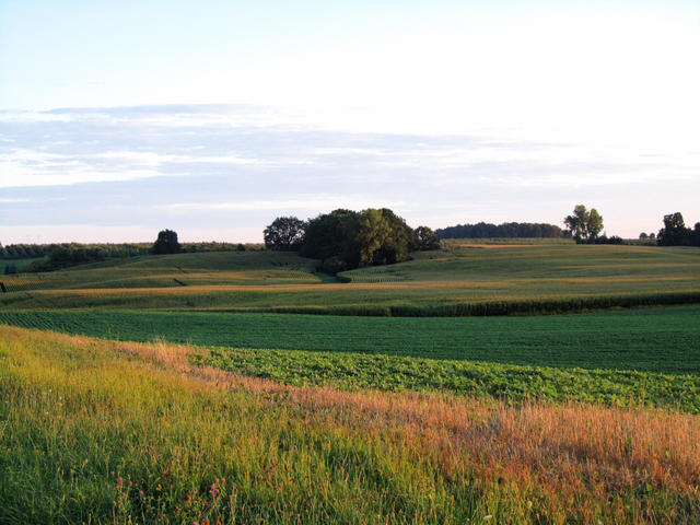 This scenery with a gently hilly landscape mostly covered in agriculture is typical of the Lake Michigan Moraines. Photo © Rachel Kramer, CC BY 2.0, Source.
Plant Lists & In-Region Search
We do not yet have data to generate plant lists for a region as fine-tuned as this one. However you can move up to the broader Southern Michigan/Northern Indiana Drift Plains and generate lists for that region: native plants or all plants. Or search that region's plants here:
↑References
1. Omernik, J.M., Bryce, S.A. "Michigan: Level III and IV Ecoregion Descriptions / Mapping Issues", US EPA (2007) Web.
2. Albert, Dennis A. "Regional landscape ecosystems of Michigan, Minnesota, and Wisconsin: a working map and classification.", General Technical Report NC-178, U.S. Department of Agriculture, Forest Service, North Central Forest Experiment Station, St. Paul, MN (1995) Web.