
Home » Regions » North America » Eastern Temperate Forests » Mixed Wood Plains » Northeastern Coastal Zone » Lower Worcester Plateau/Eastern Connecticut Upland
Lower Worcester Plateau/Eastern Connecticut Upland
Last updated: August 3rd, 2020
Page contents
↑About the Lower Worcester Plateau/Eastern Connecticut Upland
The Lower Worcester Plateau/Eastern Connecticut Upland is a relatively flat upland region stretching from central Massachusetts south into north-central Connecticut.This region has higher elevations than areas to the south, east, and west, but is flatter than other upland areas in New England. The underlying geology is diverse: north-south belts of metamorphic rock run through the region, part of the same formation existing in the region to the north, but most of the soil is formed not from this rock, but rather, on uplands from glacial till laid overtop this rock, and in valleys, from deposits of sand, gravel, and silt. There are abundant glacial lakes and ponds, and some freshwater marshes along the Quaboag and Brookfield rivers. Acidic wetlands are common, but most surface waters have moderate alkalinity.
The climate is humid and continental, slightly colder and with a slightly shorter growing season (120-160 days) than bordering lowland reasons. Precipitation is slightly lower than more coastal areas, but still high (40-50in annually) and roughly equally-distributed year-round. Late summer to early fall averages sunnier, with the rest of the year being overcast roughly half the time.
The land here was originally almost entirely forested, with significant areas of open wetlands. Forest types are transitional between oak-hickory and northern (maple-beech-birch) hardwoods, with some areas of pure oak-hickory, and some conifers. Appalachian oak-pine forests included northern red oak (Quercus rubra), white oak (Quercus alba), scarlet oak (Quercus coccinea), black oak (Quercus velutina), and chestnut oak (Quercus montana), along with eastern white pine (Pinus strobus), red maple (Acer rubrum), various hickories (Carya sp.), and other hardwoods. Upper slopes, with shallow, dry, rocky soils, featured chestnut oak, northern red oak, black oak, and some pitch pine (Pinus rigida). There were also oak-hickory forests, with northern red oak, white oak, pignut hickory (Carya glabra), shagbark hickory (Carya ovata), and mockernut hickory (Carya tomentosa).
Midslopes featured oak-hemlock-white pine forest, with various oaks, eastern hemlock (Tsuga canadensis), and white pine, along with some sweet birch (Betula lenta), black cherry (Prunus serotina), and red maple. More mesic sites supported richer forests of sugar maple (Acer saccharum), northern red oak, American beech (Fagus grandifolia), and white ash (Fraxinus americana). There were also some areas of northern hardwoods-hemlock-white pine forest. Swamps featured red maple, green ash (Fraxinus pennsylvanica), hemlock, and atlantic white cedar (Chamaecyparis thyoides). Floodplains of small rivers supported pin oak (Quercus palustris) and green ash, with some swamp white oak (Quercus bicolor), American sycamore (Platanus occidentalis), red maple, and American elm (Ulmus americana).
This area is mostly sparsely populated, although there are numerous small towns and some rural residential development. In spite of the name, the city of Worcester is located just outside this region and little of its metro area is contained here. Larger settlements include Sturbridge and Palmer, MA, and Stafford, CT. There is some agriculture, including both pasture and livestock grazing, and cropland. Major crops include hay, corn for silage, nursery stock, greenhouse products, dairy, livestock, some poultry, sweet corn, potatoes, other vegetables, and tobacco. Forest cover is significant, including upland sites and some wooded wetlands, and there are both larger, unbroken tracts of forest and smaller, fragmented forests.
This region is bordered to the west by the lower-lying, more agriculturally-developed Connecticut Valley, to the southeast by the slightly lower-altitude Southern New England Coastal Plains and Hills, and to the north by the more rugged Worcester/Monadnock Plateau. There is also a small border to the east with the Gulf of Maine Coastal Plain.
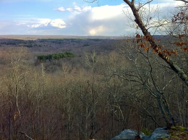 This photo, taken from the Nipmuck Trail, shows a relatively flat landscape typical of the Lower Worcester Plateau/Eastern Connecticut Upland, with forest dominated by various hardwoods. Photo © Morrow Long, CC BY-SA 2.0, Source.
Plant Lists & In-Region Search
We do not yet have data to generate plant lists for a region as fine-tuned as this one. However you can move up to the broader Northeastern Coastal Zone and generate lists for that region: native plants or all plants. Or search that region's plants here:
↑References
1. Griffith, G.E., Omernik, J.M., Bryce, S.A., Royte, J., Hoar, W.D., Homer, J.W., Keirstead, D., Metzler, K.J., and Hellyer, G. "Ecoregions of New England (Poster)", U.S. Geological Survey (2009) Web.