
Home » Regions » North America » North American Deserts » Cold Deserts » Wyoming Basin
Wyoming Basin
Last updated: August 2nd, 2023
Page contents
To check where a specific point lies, you can look it up in our Ecoregion Locator.
↑Map Legend & Subregion List
This list will help you navigate the regions in case you have problems with viewing or clicking the interactive map above.
| Name | † | Color on Map | EPA Code‡ |
| Rolling Sagebrush Steppe | ○ | 18a | |
| Bighorn Basin | ○ | 18b | |
| Sub-Irrigated High Valleys | ○ | 18c | |
| Foothill Shrublands and Low Mountains | ○ | 18d | |
| Salt Desert Shrub Basins | ○ | 18e | |
| Laramie Basin | ○ | 18f | |
| Bighorn Salt Desert Shrub Basins | ○ | 18g |
† Status: ✓ = Complete ○ = Needs Image … = Incomplete ∅ = Stub Only
‡ This code refers to the US EPA's Level 4 ecoregion codes for the continental U.S., see here.
↑Progress
Partially Complete | With Images | Complete w/ Images |
Get involved! You can help our ecoregion articles progress faster. Help us find photos of these regions. Contact us if you have any additions or corrections to any of these articles. You can also donate to support our ongoing work.
↑About the Wyoming Basin
The Wyoming Basin is a region of Wyoming covering most of the lower, flatter areas of the state that lie west of the easternmost portion of the Rockies, and extending barely into southeastern Idaho, northeastern Utah, and slightly into northwestern Colorado. This region is mostly surrounded by mountains, creating rain shadow as well as a slightly sheltered climate with less continental influence.The climate here is cold and dry, ranging from arid to the drier end of a semiarid (steppe) climate. Precipitation here has an asymmetrical, weakly bimodal seasonality, with both a spring and fall wetter season and drier summers and winters. This pattern is markedly different from the pattern on the open plains farther east, which has a more unimodal pattern. Here, the spring brings highest rainfall, peaking usually in May although peaking as late as June in the north of the region. Spring is followed by a hot, dry summer. The fall rainy season is less pronounced, and peaks in September or October in most of the region. There is some chance of precipitation at any time of year, and even the wettest months are still quite dry. There are large variations in temperature between day and night, and also significant variation from day to day; frost is possible at any time of year. A significant portion of the total precipitation here falls as snow, and the snow has disproportionate importance to plants because it is more likely to melt slowly and be able to be absorbed by plants rather than quickly evaporating. At the same time, this region is sheltered by mountains from some of the more extreme weather found on the great plains; relative to areas east of the mountains, it has fewer tornados and severe thunderstorms, and a slight blunting of the large temperature swings associated with the movement of large air masses across open parts of the continent.
This region spans the continental divide, with the westernmost portions of this region ultimately draining into the Pacific ocean, via the Colorado river, whereas the eastern regions drain eastward into the Mississippi river and ultimately the Gulf of Mexico. Part of the interior of this region contains a small region called the Great Divide Basin, which is endorheic (not draining to the outside), and can be divided into four separate basins, each with its own watershed.
The terrain here is somewhat diverse. There are broad basins that are nearly completely flat, as well as more gently-sloping areas and occasional steeper hills and low mountains. Uplands tend to have a dissected drainage pattern, and there are also areas of tablelands with broad canyons cut into them. Overall this region is much flatter and less interrupted by mountains than the Central Basin and Range to the southwest. Streams here are mostly ephemeral, although there are a few perennial streams that originate in bordering mountains. Some seasonal lakes form in the endorheic basins. Although this region is mostly lower in elevation than its surroundings, it is still a high elevation region, with elevations beginning at about 4,000 ft (1,220m) above sea level and reaching upwards to 10,037 ft (3,059 m) at Ferris Peak.
The vegetation ranges from arid grasslands to low scrubland. Dominant grassland vegetation includes Wyoming big sagebrush (Artemisia tridentata subsp. wyomingensis), black sagebrush (Artemisia nova), fringed sagebrush (Artemisia frigida), rabbitbrush, western wheatgrass (Pascopyrum smithii), needle-and-thread grass (Hesperostipa comata), blue grama (Bouteloua gracilis), and prairie junegrass (Koeleria macrantha). Desert shrublands feature greasewood (Sarcobatus vermiculatus), gardner's saltbush (Atriplex gardneri), shadscale saltbush (Atriplex confertifolia), bud sagebrush (Artemisia spinescens), and at the moister, higher elevations, big sagebrush and pinyon-juniper woodland, with open forest of douglas fir (Pseudotsuga menziesii) at the highest elevations. The driest parts of this region have some areas of sand dunes devoid of vegetation.
This region is heavily utilized for mining, with mining of coal, trona, bentonine, clay, and uranium. There is some livestock graving around the more heavily-vegetated portions of the region, although much of the region is too arid and devoid of vegetation to be used for rangeland. There are small amounts of cropland made possible by irrigation. Although most of this region is essentially unpopulated, there are some small cities, the largest of which is Laramie, followed by Rock Springs, and then Evanston and Green River. There are also numerous small towns. Casper, larger than any of these cities, lies just outside this region to the east. Most of the population is concentrated along the east-west corridor of I-80, which cuts across the southern portion of this region.
This region is mostly surrounded by mountains, with higher elevations, more rugged terrain, higher rainfall, and denser vegetation cover. To the northwest and parts of the northeast lie the Middle Rockies. To the southwest lie the Wasatch and Uinta Mountains, and to the southeast are the Southern Rockies. There is also a rather large gap in the northeast where this region opens directly to the Northwestern Great Plains in the east, an area with slightly more rainfall but also more extreme weather. At the south, there is also a significant gap between the mountains, and a direct border with the Colorado Plateaus, an area of tablelands that has more woodland cover, mostly pinyon-juniper and gambel oak.
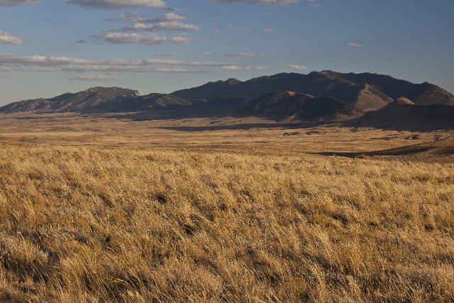 This photo shows one of the more protected areas of the Wyoming Basin, with the Ferris Mountains in the background. The flat landscape in the foreground is more typical of the region, although there are a few areas of low mountains, the largest of which are the ones pictured here. Photo © US Bureau of Land Management, Public Domain, Source.