
Home » Regions » North America » Northwestern Forested Mountains » Western Cordillera » Southern Rockies
Southern Rockies
Last updated: September 19th, 2023
Page contents
To check where a specific point lies, you can look it up in our Ecoregion Locator.
↑Map Legend & Subregion List
This list will help you navigate the regions in case you have problems with viewing or clicking the interactive map above.
| Name | † | Color on Map | EPA Code‡ |
| Alpine Zone | ○ | 21a | |
| Crystalline Subalpine Forests | ○ | 21b | |
| Crystalline Mid-Elevation Forests | ○ | 21c | |
| Foothill Shrublands | ○ | 21d | |
| Sedimentary Subalpine Forests | ○ | 21e | |
| Sedimentary Mid-Elevation Forests | ○ | 21f | |
| Volcanic Subalpine Forests | ○ | 21g | |
| Volcanic Mid-Elevation Forests | ○ | 21h | |
| Sagebrush Parks | ○ | 21i | |
| Grassland Parks | ○ | 21j |
† Status: ✓ = Complete ○ = Needs Image … = Incomplete ∅ = Stub Only
‡ This code refers to the US EPA's Level 4 ecoregion codes for the continental U.S., see here.
↑Progress
Partially Complete | With Images | Complete w/ Images |
Get involved! You can help our ecoregion articles progress faster. Help us find photos of these regions. Contact us if you have any additions or corrections to any of these articles. You can also donate to support our ongoing work.
↑About the Southern Rockies
The Southern Rockies are a region encompassing the southeasternmost portion of what is called the Rocky Mountains, and are the portion of these mountains that people most frequently think of, in part due to their being warmer, more accessible to tourism, and closer to population centers. This region occupies much of central to western Colorado, and extends slightly into southern Wyoming and northern New Mexico, with two small discontiguous pieces in eastern Utah.The region has a humid continental climate with large temperature swings between day and night, varying to a subarctic climate at the highest elevations, and becoming semi-arid at the lowest elevations. Unlike mountainous regions farther north, west, or south, there is almost no seasonality of precipitation, with roughly equal quantities of rainfall equivalent falling year-round. In winter most precipitation falls as snow, and snowfall totals can be quite high. The influence of continental air masses is different in different portions of this region; the east is more subject to motions of air masses from the north or south, which can lead to sometimes prolonged hot or cold spells, whereas the west is more protected from such weather and has less day-to-day or week-to-week variation in climate. Lower-elevation areas in the interior of this region are even more protected from these air masses and have even less day-to-day variation in climate, even if their night-to-day temperature variation is still large.
The terrain here consists of steep, rugged mountains. There are examples both of long, linear ranges, and collections of isolated peaks, and especially around the edges of the region, there are also areas of dissected plateaus. Mid-to-high elevations have been glaciated, and there are some broad, flat valleys at high elevations. The underlying geology is diverse, including both metasedimentary and metavolcanic rocks, as well as some intrusions of igneous rock, as well as layers of sedimentary rock and some volcanic rocks. Soils here are varied, including alfisols (relatively fertile, well-developed soils), entisols (poorly-developed soils, mostly in steeper areas and on harder bedrocks that are less-readily weathered), and mollisols (fertile soils forming mostly under savannas and grasslands in valleys.) As such the soil fertility and plants able to be supported by the soil varies widely from site to site, which, combined with topographic variability, leads there to be high diversity in plant cover.
Because of the high rainfall and steep topography, there are numerous fast-moving, rocky-bottomed streams throughout, which coalesce into a variety of larger rivers that eventually flow out of this region. These rivers include the Colorado River, which is one of the key water sources for much of the southwest and drains much of the west of this region, the Arkansas River, which drains the Sawatch and Mosquito ranges, the South Platte River, which drains most of the eastern flank of this region and flows through Denver, and the North Platte River, which flows north into the Wyoming Basin. These rivers are fueled largely by snowmelt, which leads their flow to increase seasonally even though total precipitation here is less seasonal. There are also a number of natural alpine lakes, as well as some artificially-constructed reservoirs. The region spans the continental divide, with the eastern portion draining into the Atlantic ocean through the Gulf of Mexico, and the west draining into the Pacific.
Much of this region is covered by coniferous forest, but there is significant variation of cover by altitude. Ecosystems tend to form bands following changes in elevation. The lowest elevations support open grassland and/or shrubs, transitioning to savanna, featuring sagebrush, alderleaf mountain mahogany (Cercocarpus montanus), twoneedle pinyon (Pinus edulis), juniper, and scattered gambel oak (Quercus gambelii). Increasing in elevation, one finds juniper-oak woodlands, ponderosa pine (Pinus ponderosa), douglas fir (Pseudotsuga menziesii), and quaking aspen (Populus tremuloides). Mid-to-high elevations feature forests of engelmann spruce (Picea engelmannii), subalpine fir, and quaking aspen. The highest elevations become open again, supporting cushion plants, sedges, and stunted or krummholz forms of trees including spruce, fir, pine, and various low shrubs. There are numerous rock outcroppings or barren areas at the highest elevations.
Land use here is diverse, including forestry, mining of precious metals including gold, copper, and silver, tourism and recreation, cattle ranching and other livestock grazing, and some rural residential development. A large portion of this region is preserved as public land, mostly federally as national parks, national forests, or national monuments. This region is also critically important for water supply, and not just because of reservoirs located here, but because of the flow of water out of this region into areas where water is scarce. Unfortunately, the water originating in this region is not being used sustainably, and much of the water that historically originated here is used up before it reaches its final destination, much to the detriment of ecosystems in other regions, particularly to the southwest.
Relative to the steepness of the terrain, there is a well-developed road network through this region, making most of it relatively accessible. Although this region is sparsely populated, it has more population than mountainous areas farther north. The largest towns here and only two with populations over 10,000 are Steamboat Springs, and Los Alamos, NM, followed by Glenwood Springs, and somewhat smaller, Aspen, Gunnison, Estes Park, and Breckenridge. Outside of Los Alamos, the rest of these cities and towns are all in Colorado. Some larger cities are located just outside of this region, the largest of which is Denver.
This region is surrounded to the north, west, and south by the Cold Deserts, a colder, lower-elevation region. In the north it borders the grass-dominated Wyoming Basin, whereas in the west it borders the Colorado Plateaus, which has sparser vegetation of mostly scrub, and in the south, the Arizona/New Mexico Plateau; these two regions mostly of tablelands. In the east, this region borders the South Central Semi-Arid Prairies, more specifically the High Plains in the north and the Southwestern Tablelands in the south. An exception is at the far north in Wyoming where this region borders the Northwestern Great Plains to the north; together these are the more arid portion of the Great Plains. All of these regions are drier and lower in elevation; together they isolate this region to where it is disconnected from other areas of similar climate and vegetation cover, which has led this region to have a high portion of endemic species.
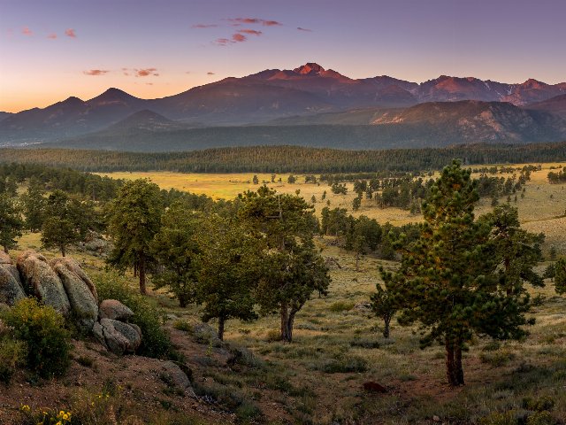 This striking landscape shows the typical range of vegetation cover in the Southern Rockies, from open grasslands in valleys, to savannas and then coniferous forest as elevations increase, which then open again to more open habitats near mountain summits. Crop of a photo © Christian Collins, CC BY-SA 2.0, Source.