
Home » Regions » North America » North American Deserts » Cold Deserts » Snake River Plain
Snake River Plain
Last updated: May 30th, 2023
To check where a specific point lies, you can look it up in our Ecoregion Locator.
↑Map Legend & Subregion List
This list will help you navigate the regions in case you have problems with viewing or clicking the interactive map above.
| Name | † | Color on Map | EPA Code‡ |
| Treasure Valley | ○ | 12a | |
| Lava Fields | ○ | 12b | |
| Camas Prairie | ○ | 12c | |
| Dissected Plateaus and Teton Basin | ○ | 12d | |
| Upper Snake River Plain | ○ | 12e | |
| Semiarid Foothills | ○ | 12f | |
| Eastern Snake River Basalt Plains | ○ | 12g | |
| Mountain Home Uplands | ○ | 12h | |
| Magic Valley | ○ | 12i | |
| Unwooded Alkaline Foothills | ○ | 12j |
† Status: ✓ = Complete ○ = Needs Image … = Incomplete ∅ = Stub Only
‡ This code refers to the US EPA's Level 4 ecoregion codes for the continental U.S., see here.
↑Progress
Partially Complete | With Images | Complete w/ Images |
Get involved! You can help our ecoregion articles progress faster. Help us find photos of these regions. Contact us if you have any additions or corrections to any of these articles. You can also donate to support our ongoing work.
↑About the Snake River Plain
The Snake River Plain is a broad, crescent-shaped valley located mostly within southern Idaho, stretching slightly into Oregon and barely reaching a tiny portion of Wyoming. As the name suggests, it centers around the Snake river, which is fed by streams and rivers flowing in from surrounding mountainous regions, primarily areas to the north and east, with less water arriving from the west and south. The river flows west and north, flowing into the Columbia river and then the Pacific Ocean.The region has a semi-arid steppe climate with strong seasonality of temperature and precipitation. The bulk of water available here arrives from surrounding regions, with only small amounts falling as precipitation. Summers are warm to hot, with little rainfall, especially in the west, whereas the remainder of the year is slightly wetter, with precipitation peaking in May and, in the west of the region, also in December. Temperatures decrease significantly (by about 10°F / 5.5°C) moving from west to east, owing to a gradual increase in elevation, but there is no appreciable increase in precipitation. The frost-free period varies from 50 to 170 days. There is a large temperature variation from day to night, especially in summer, and there can be significant variation in weather from day to day. Winters are cold and there is usually some persistent snowfall.
The terrain here is flatter than most of the surrounding regions, mostly consisting of flat to gently-sloping plains and alluvial valleys, with some low hills and scattered lava fields. There are, however, some steep escarpmentments along the river valley, and some steep-walled canyons around the edges of this region. Soils here tend to be alkaline and somewhat saline, especially on the drier sites, with a higher concentation of minerals than is ideal for plant growth, however, there are areas of richer soils that formed under grasslands, and the soils are often suitable for agriculture with irrigation.
Naturally this area was covered with sagebrush steppe, with dominant plants being Wyoming sagebrush, bigbasin sagebrush, mountain sagebrush, bluebunch wheatgrass, Idaho fescue, Indian ricegrass, rabbitbrush, and fourwing saltbush. Vegetation on lava fields is sparse.
The areas closest to the Snake river have been heavily developed for agriculture, using the river for irrigation. Canals and reservoirs have altered the natural structure of waterways. The main crops grown here include sugar beets, potatoes, alfalfa, various small grains, and assorted vegetables. There are also cattle feedlots and dairy farming. Farther from the river, rangeland is common. Although Idaho is not the most populous state, this region is the most urbanized portion of it, containing all but one of the state's largest cities: Boise, Meridian, Nampa, Idaho Falls, Pocatello, Caldwell, and Twin Falls are all located here.
This region is bordered to the south and west by the Northern Basin and Range, a region that is drier overall, and has more variable topography; this border is marked by a watershed divide, with the southern region draining into the endorheic Great Basin. In the east, this region is bordered to the east and north by the Middle Rockies, a mountainous region. In the west, it is bordered to the north and east by the Idaho Batholith, another mountainous region that has slightly higher rainfall than the Middle Rockies, and it also shares a small border to the northwest with the Blue Mountains, a region of lower, more open mountains.
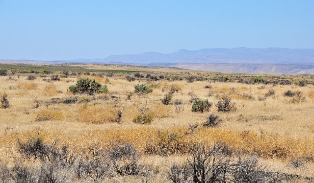 This photo shows a landscape typical of the Snake River Plain in summer; this view looks towards the river, which is not visible due to the river being at a lower elevation, bordered by steep escarpments. This region is rather barren, mostly covered in sagebrush steppe in which most of the vegetation is dormant during the hot, dry summer. The terrain is mostly relatively flat but is surrounded by more rugged regions. Photo © Jess Johnson, CC BY 2.0, Source.
Plant Lists & In-Region Search
↑References
1. Wiken, E., Griffith, G. "North American Terrestrial Ecoregions - Level III", Commission for Environmental Cooperation, (2011) Web.