
Home » Regions » North America » Northwestern Forested Mountains » Western Cordillera » Idaho Batholith
Idaho Batholith
Last updated: September 7th, 2022
Page contents
To check where a specific point lies, you can look it up in our Ecoregion Locator.
↑Map Legend & Subregion List
This list will help you navigate the regions in case you have problems with viewing or clicking the interactive map above.
† Status: ✓ = Complete ○ = Needs Image … = Incomplete ∅ = Stub Only
‡ This code refers to the US EPA's Level 4 ecoregion codes for the continental U.S., see here.
↑Progress
Partially Complete | With Images | Complete w/ Images |
Get involved! You can help our ecoregion articles progress faster. Help us find photos of these regions. Contact us if you have any additions or corrections to any of these articles. You can also donate to support our ongoing work.
↑About the Idaho Batholith
The Idaho Batholith is a portion of the Rocky Mountains mostly located in central Idaho and extending slightly into western Montana. It consists of rugged mountains with deep, steep-walled canyons, ranging from open scrubland to coniferous forests. Soils tend to be poor and there is not particularly intensive land use.The climate here is towards the arid end of a humid continental climate, and the region as a whole can be seen as transitioning between a semiarid climate in the south and a humid climate farther north. Precipitation is seasonal, with wet winters and dry summers, reminiscent of a Mediterranean climate but with more extreme swings of temperature. There are large temperature swings between day and night, especially in the south. Maritime influence tends to increase towards the north of this region, leading to higher precipitation and more moderate temperatures.
This region consists mostly of a mountainous plateau dissected by streams and rivers, deeply in places, and also shaped by irregular, partial alpine glaciation. This region was never connected to the larger ice sheets farther north, but did support local alpine glaciers that have since melted. There are some extraordinarily deep canyons here, with differences of over 4,000 feet from the valley bottom to ridgetops. Much of this region consists of intrusive igneous rock that has been deeply weathered, producing soils that are acidic, nutrient-poor, and also poor at holding water. The combination of these soils with the steep topography and somewhat arid climate leaves the ecosystems in this region prone to degradation following disturbances such as logging. The richest soils here tend to be either found in the valleys where they formed under grasslands, or in places where soils formed on volcanic ash.
Vegetation cover varies considerably by elevation. Much of the region is dominated by grand fir (Abies grandis) and douglas fir (Pseudotsuga menziesii); higher elevations also feature engelmann spruce (Picea engelmannii) and subalpine fir (Abies lasiocarpa) and the highest elevations open to alpine meadows and exposed rock. The lowest elevations feature more open scrublands with scattered ponderosa pine (Pinus ponderosa), sagebrush (Artemisia sp.) and other shrubs, and grasses. Tree cover tends to become denser in increasing elevation to a point, and then decrease again at the highest elevations, with trees limited by precipitation at low elevations and by cold temperatures and thin soils closer to peaks.
The dominant land uses here are logging, grazing, and recreation. There is a substantial history of mining in this region, which has extensively degraded the waterways here. This region is sparsely populated. The only settlements of appreciable size are McCall, Ketchum, and the unincorporated community of Cascade, all in Idaho and all located in low-elevation valleys around the margins of this region. A huge portion of this region is left wild, including both protected public land and privately-owned lands. Public land here includes Salmon-Challis, Boise, Bitterroot, and Nez Perce-Clearwater National Forests, and Selway-Bitterroot Wilderness which is one of the largest wilderness areas in the US. Overall, this area is not as intensively utilized as many nearby regions due to its inaccessibilty, more arid climate, and poor soils.
This region is bordered to the north by the more humid Northern Rockies, and to the east by the Middle Rockies, a slightly more arid region with broader, more barren valleys. To the west it is bordered by the Blue Mountains, a range of lower, more open mountains that is also slightly more arid. To the south it is borederd by the Snake River Plain, a low, flat region along the Snake River, where there is intensive agriculture utilizing the river for irrigation.
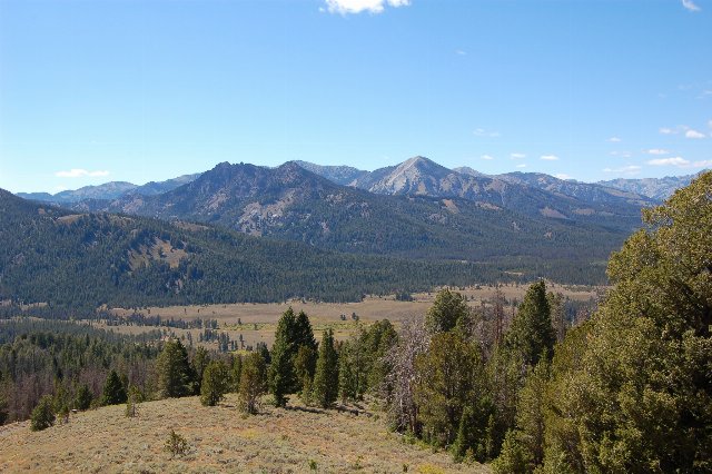 This photo, taken from just under 8,500 feet, shows the Sawtooth Range in Idaho, part of the Idaho Batholith. The landscape of coniferous forests on the slopes opening to scrubland and grassland in valleys and also towards peaks is typical of this region. Photo © Stephen Hanafin, CC BY-SA 2.0, Source.