
Home » Regions » North America » Northwestern Forested Mountains » Western Cordillera » Wasatch and Uinta Mountains
Wasatch and Uinta Mountains
Last updated: May 31st, 2023
Page contents
To check where a specific point lies, you can look it up in our Ecoregion Locator.
↑Map Legend & Subregion List
This list will help you navigate the regions in case you have problems with viewing or clicking the interactive map above.
| Name | † | Color on Map | EPA Code‡ |
| Alpine Zone | ○ | 19a | |
| Uinta Subalpine Forests | ○ | 19b | |
| Mid-Elevation Uinta Mountains | ○ | 19c | |
| Wasatch Montane Zone | ○ | 19d | |
| High Plateaus | ○ | 19e | |
| Semiarid Foothills | ○ | 19f | |
| Mountain Valleys | ○ | 19g |
† Status: ✓ = Complete ○ = Needs Image … = Incomplete ∅ = Stub Only
‡ This code refers to the US EPA's Level 4 ecoregion codes for the continental U.S., see here.
↑Progress
Partially Complete | With Images | Complete w/ Images |
Get involved! You can help our ecoregion articles progress faster. Help us find photos of these regions. Contact us if you have any additions or corrections to any of these articles. You can also donate to support our ongoing work.
↑About the Wasatch and Uinta Mountains
The Wasatch and Uinta Mountains is a region of mountains and plateaus located mostly in Utah and extending barely into southwestern Wyoming and southeastern Idaho. This region includes the east-west-trending Uinta Mountains in northern Utah, which are slightly taller, and the longer north-south trending Wasatch Range. Although geologically distinct, these ranges border each other and produce climactically- and ecologically-similar regions and are thus lumped together. This region also marks a major watershed divide between the Central Basin to the west, Wyoming Basin to the northeast, and the Colorado River watershed to the southeast.Most of this region has a humid continental climate, ranging to a semiarid climate in the valleys, and subalpine to alpine climates at the highest elevations. Precipitation is somewhat seasonal, with dry summers (June-August) and around twice the precipitation falling in the wettest months than the driest months. Significant snow falls from November through April, with totals much higher at the high elevations. High elevations, especially in the north, accumulate so much snow that avalanches are common. The slightly drier summers bring large temperature swings between hot days and cool nights.
This region consists of high, steep mountains with narrow crests and valleys that opens up in places to dissected plateaus and more open high mountains. The highest elevations, particularly in the Uinta Mountains, have been heavily glaciated and are marked with glacial features including U-shaped valleys, hornes, aretes, moraines, and cirques. The geology of this region is complex and varied, with a mix of sedimentary rocks, igneous rocks of varying ages, and metamorphic rocks. Soils vary extensively by topography and geology, but overall this region tends to have relatively rich soils on flatter sites where soil has had time to develop and accumulate, and poorly-developed, rocky soils on the steepest terrain.
The vegetation here varies by altitude and follows a similar pattern to that of the Southern Rockies farther to the east, except that there is a greater portion of quaking aspen (Populus tremuloides), chaparral, and Juniper-pinyon woodland at mid elevations. There are also similarities to the Middle Rockies farther north, but with much less lodgepole pine (Pinus contorta), a species that meets its southern range limits in this region. Valleys have the most open vegetation cover, with sagebrush, grasses, and scattered pinyon and utah juniper (Juniperus osteosperma). Foothills mostly support pinyon-juniper woodland and sagebrush, with scrubby growth of maple and gambel oak (Quercus gambelii) appearing in the north. Middle elevations have some ponderosa pine (Pinus ponderosa), which occupies a relatively narrow elevation range, giving way to more diverse forests of douglas fir (Pseudotsuga menziesii), quaking aspen, subalpine fir (Abies lasiocarpa), engelmann spruce (Picea engelmannii), and limber pine (Pinus flexilis). The highest altitudes open to alpine meadows with low shrubs and herbaceous plants, interspersed with barren rock outcroppings.
Although this region itself is relatively sparsely populated, as the most water-rich region of Utah, most of Utah's population is concentrated just outside the western border of this region, where rivers and streams exit the mountains. As such, land use in the west of this region is more intense than typical for other similarly-rugged mountainous regions surrounded by deserts. There is extensive forestry, ranching, and livestock grazing here, as well as recreation, and small amounts of agriculture in the valleys. In recent years there has also been increasing residential development in the valleys; the western border of this region is steep and cannot easily support such development. There is an extensive road network here, with roads through all the major passes. Large areas of this region are protected as public lands. The east of this region, the Uinta Mountains, is relatively untouched. Most of this region is sparsely populated. The largest city is Heber City, followed by Park City, and then Morgan, all in Utah, and all located in valleys on the east slopes of the Wasatch Range.
In the north, there is a narrow border with the Middle Rockies, a similar but colder mountainous region. This region is bordered to the west by the Central Basin and Range, an endorheic basin which is largely arid, but interspersed by north-south mountain ranges that are generally smaller and much lower than this region. To the northeast, it is bordered by the Wyoming Basin, another separate endorheic region that is much flatter than the Central Basin, and largely devoid of mountain ranges. To the southeast, this region is bordered by the Colorado Plateaus, a region that consists of varying levels of plateaus, separated by dissected escarpments, and that eventually drains into the Colorado river and then Pacific ocean.
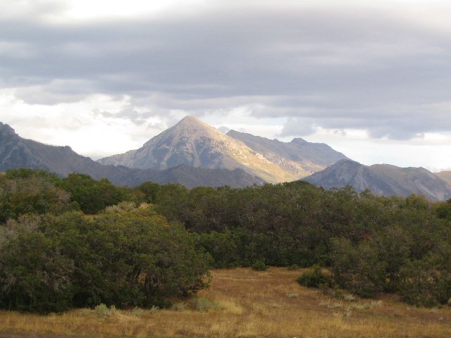 This photo shows Mount Timpanogos, taken from Corner Canyon near Draper, Utah. This mountain is the second-highest peak in the Wasatch range, and this landscape shows the full range of vegetation cover in the region, from open grassland, to scrubland, through coniferous forest and opening to alpine meadows and rock outcroppings at the highest elevations. Photo © Ken Lund, CC BY-SA 2.0, Source.