
Home » Regions » North America » North American Deserts » Cold Deserts » Central Basin and Range
Central Basin and Range
Last updated: May 31st, 2023
Page contents
To check where a specific point lies, you can look it up in our Ecoregion Locator.
↑Map Legend & Subregion List
This list will help you navigate the regions in case you have problems with viewing or clicking the interactive map above.
† Status: ✓ = Complete ○ = Needs Image … = Incomplete ∅ = Stub Only
‡ This code refers to the US EPA's Level 4 ecoregion codes for the continental U.S., see here.
↑Progress
Partially Complete | With Images | Complete w/ Images |
Get involved! You can help our ecoregion articles progress faster. Help us find photos of these regions. Contact us if you have any additions or corrections to any of these articles. You can also donate to support our ongoing work.
↑About the Central Basin and Range
The Central Basin and Range is a large endorheic (internally-draining) region occupying much of Nevada and western Utah, and reaching slightly into eastern California. It consists of a mix of desert basins with long, frequently-broken mountain ranges. It makes up the southwesternmost portions of what is typically referred to as the Great Basin.The climate here is towards the warmest end of what our classification scheme treats as Cold Deserts. Temperatures here vary more by elevation than by latitude. Most of the region is arid to semi-arid, but the climate becomes more humid at the highest elevations. Precipitation is seasonal, with summers being driest, and throughout most of the region, precipitation peaking in winter or spring. The timing of the precipitation peak varies regionally, happening in winter in the southwestern most parts of the region and a bit later, late winter or early spring in most of the region. Warm-season precipitation mostly arrives during thunderstorms, whereas winter precipitation usually arrives as snow, with snow common through April, and into May at higher elevations.
This region has varied topography; the general trend is that of long north-south ridges separated by broad valleys. Most of the mountains were formed as uplifted fault blocks and thus have steep slopes. Streams here are mostly ephemeral, either seasonal or even more temporary, appearing only in response to large rain events. The few perennial streams are found only in the mountains. Features in the basins include playas (dry lakes), salt flats, sand dunes, terraces, and low hills. There are gently-sloping alluvial fans where the larger streams flow out of the mountains into the basins.
Because of the internal drainage, soils in the basins tend to be saline and/or sodic soils with an excess of sodium and other salts, enough to hinder plant growth. These soils tend to be very deep. Because of the arid nature of these basins and the lack of vegetation, there are also significant areas of recently-deposited sediment that have not developed into soil.
Although the total amount of vegetation here is sparse, the diversity in vegetation cover type is high. The arid basins here are mostly covered in either big sagebrush (Artemisia tridentata) or a mixture of saltbush and greasewood. There are fewer cool-season grasses here than in regions to the north. The more common vegetation includes shadscale saltbush (Atriplex confertifolia), winterfat (Krascheninnikovia lanata), black sagebrush (Artemisia nova), Wyoming big sagebrush (Artemisia tridentata subsp. wyomingensis), Nevada jointfir (Ephedra nevadensis), mormon tea (Ephedra viridis), rabbitbrush, indian ricegrass (Achnatherum hymenoides), and squirreltail (Elymus elymoides). More saline areas feature Greasewood, nuttall's saltbush (Atriplex nuttallii), pursh seepweed (Suaeda calceoliformis), mojave seablite (Suaeda nigra), and alkali sacaton (Sporobolus airoides). Lower elevations of mountains support singleleaf pinyon (Pinus monophylla), Utah juniper (Juniperus osteosperma), sagebrush, bitterbrush (Purshia sp.), Utah serviceberry (Amelanchier utahensis), snowberry (Symphoricarpos sp.), and bluebunch wheatgrass (Pseudoroegneria spicata). The highest elevations support some open forests of Douglas fir (Pseudotsuga menziesii), white fir (Abies concolor), limber pine (Pinus flexilis), whitebark pine (Pinus albicaulis), and quaking aspen (Populus tremuloides).
In addition to the common and widespread vegetation, the varied topography with isolated "islands" of habitats of higher elevation, interspersed with unconnected basins separated by mountain ranges, leads this area to have a high density of endemic species, including plants. This region is also home to the great basin bristlecone pine (Pinus longaeva), a tree that may hold the record of the longest-lived non-clonal tree ever recorded.
Land use in most of this region is not particularly intensive. There is significant ranching and livestock grazing, however, as well as mining, including for gold, silver, and mercury. Significant portions of this region exist as public protected land, much of it managed for wildlife conservation, including public rangeland and national forest. Some of the land here is owned by the military, and there are also some Native American lands. There is a small amount of agriculture in the Diamond Valley near Eureka, NV, fueled by groundwater; this irrigation is used primarily to grow hay, and the use of the groundwater has been unsustainable and is rapidly depleting the aquifer.
Most of this region is sparsely populated, but there is significant urbanization around its outskirts. Reno, NV is the largest city here, and nearby is Carson City, NV, both of which are at the southwestern border of this region. Salt Lake City, UT, the second-largest city here, straddles the eastern border of this region, and nearby are Provo, UT, and Odgen, UT. All of these cities have significant suburbanization around them. There are very few settlements in the interior; the largest is probably Ely, NV, home to only a few thousand people, and there are a number of other smaller towns. This region is also home to Burning Man, a 9-day event that attracts many tens of thousands of people; this event is located in Black Rock Desert, one of the driest portions of this region, and involves construction of a temporary city called Black Rock City, which at the time would be the largest city in the interior of this region.
This region is bordered to the north by the geologically-similar, but colder Northern Basin and Range. To the south it is bordered by the hotter, drier Mojave Basin and Range. To the east, it is borederd abruptly by the Wasatch and Uinta Mountains, a mostly north-south mountain range that is larger and less interrupted than any of the local ranges in this region. To the west, it is bordered by the Sierra Nevada, a taller, thicker north-south mountain range with higher rainfall and more forest cover.
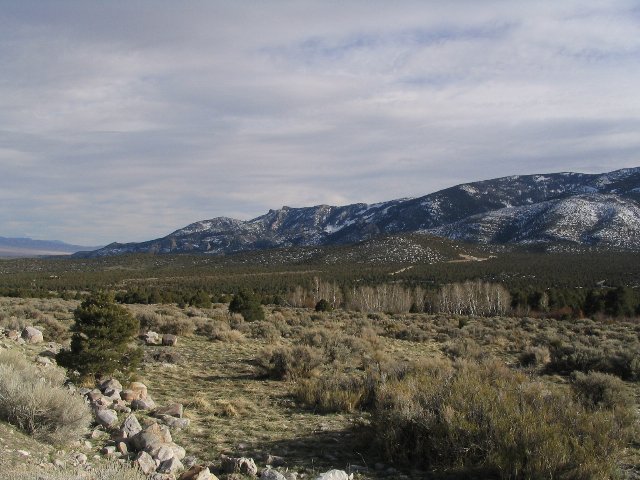 This photo, taken from Wheeler Peak Scenic Drive in Great Basin National Park, Nevada, shows some of the protected public land in the Central Basin and Range. This region consists of north-south mountains interspersed with arid basins with internal drainage. Photo © Ken Lund, CC BY-SA 2.0, Source.