
Home » Regions » North America » North American Deserts » Cold Deserts » Colorado Plateaus
Colorado Plateaus
Last updated: August 8th, 2023
Page contents
To check where a specific point lies, you can look it up in our Ecoregion Locator.
↑Map Legend & Subregion List
This list will help you navigate the regions in case you have problems with viewing or clicking the interactive map above.
| Name | † | Color on Map | EPA Code‡ |
| Monticello-Cortez Uplands | ○ | 20a | |
| Shale Deserts and Sedimentary Basins | ○ | 20b | |
| Semiarid Benchlands and Canyonlands | ○ | 20c | |
| Arid Canyonlands | ○ | 20d | |
| Escarpments | ○ | 20e | |
| Uinta Basin Floor | ○ | 20f | |
| Northern Uinta Basin Slopes | ○ | 20g | |
| Sand Deserts | ○ | 20h | |
| Cold Desert Sagebrush-Grasslands | ○ | 20i |
† Status: ✓ = Complete ○ = Needs Image … = Incomplete ∅ = Stub Only
‡ This code refers to the US EPA's Level 4 ecoregion codes for the continental U.S., see here.
↑Progress
Partially Complete | With Images | Complete w/ Images |
Get involved! You can help our ecoregion articles progress faster. Help us find photos of these regions. Contact us if you have any additions or corrections to any of these articles. You can also donate to support our ongoing work.
↑About the Colorado Plateaus
The Colorado Plateaus constitute a region occupying most of eastern and southern Utah, the westernmost portions of Colorado, and extending barely into the northernmost portions of Arizona and northwest New Mexico. This region, owing to its visually-dramatic scenery and relative accessibility, is one of the most charismatic and better-known parts of the western US.The climate here is an arid to semiarid steppe climate. Winters are quite cold, but there is a much longer frost-free period than the region to the north, which has essentially no frost-free period. Precipitation here has minimal seasonality, excepting for a dry June followed by a slightly wetter period from July through September. For the most part, precipitation is roughly equally distributed throughout the year, but relative humidity is usually lower in summer. Elevations tend to decrease moving southward, magnifying the increase in temperatures due to solar radiation, so temperatures increase more moving south in this region than is typical. The south of this region is also drier.
The terrain here mostly consists of rugged tablelands made of sedimentary rocks, with alternating layers of sandstone and shale, with some limestone and marlstone. The sandstone layers resist erosion, whereas the shale erodes quickly. Where the upper layers of sandstone are intact, there are large, flat areas that drop precipitously into steep-walled canyons; where these layers are mostly eroded with only small areas left, there are mesas and buttes.
Local relief can be large, often 300-600m (984-1969 feet.) Smaller streams, particularly those originating in this region, are mostly ephemeral or intermittent, but there are some perennial streams originating in neighboring mountains, as well as the Colorado river which flows through this region. Most of its tributaries in this region are ephemeral. Streams and washes flow through steep-walled canyons in places, but there are also some broad bottomlands, many of which were formed by older geologic processes and currently do not have streams large enough to form them, and are thus very arid. The level of dissection of the terrain is irregular, with large expanses of essentially undissected plateau in places, to heavily-dissected terrain in others, particularly in the area around Canyonlands National Park and southward, and also in escarpments towards the northern end of this region and along the western border; in between are broad, flat areas. Lake Powell, an artificial reservior on the Colorado River, is located towards the south of this region, along the Colorado river.
Vegetation cover is sparse, but contains a greater portion of woody plants than areas to the north, and fewer grasses and few herbaceous plants in general. Low elevations have sparse growth of blackbrush (Coleogyne ramosissima), shadscale saltbush (Atriplex confertifolia), fourwing saltbush (Atriplex canescens), and James' galleta (Hilaria jamesii). Uplands and higher-elevation valleys feature Wyoming big sagebrush (Artemisia tridentata ssp. wyomingensis), black sagebrush (Artemisia nova), pinyon-juniper woodlands at the higher elevations, and at the highest elevations, a mix of Gambel oak (Quercus gambelii), alderleaf mountain mahogany (Cercocarpus montanus), quaking aspen (Populus tremuloides), and some Douglas fir (Pseudotsuga menziesii). The steeper terrain, including rock outcroppings, cliffs, and talus slopes, areas with almost no soil development, are almost completely devoid of vegetation, often with only a few small plants in sheltered crevices.
Land use here is diverse but not particularly intensive. There is significant ranching and livestock grazing, oil and gas extraction, coal mining, and recreation and tourism. There are some Native American reservations, and significant areas of national parks and monuments, including Arches, Canyonlands, and Capitol Reef National Parks, Glen Canyon National Recreation Area, and Grand Staircase Escalante National Monument. There are small amounts of cropland here, made possible through irrigation, producing pinto beans, hay, alfalfa, and winter wheat. There are also a few irrigated fruit orchards. One of the largest environmental impacts here has been from the creation of Lake Powell through the Glen Canyon Dam, which has created cascading environmental problems both downstream and upstream.
Most of this region is essentially unpopulated but there are significant areas of urbanization, mostly concentrated in Colorado, in shale basins towards the eastern border of this region, close to the Rockies. The largest city here is Grand Junction, CO, part of a metro area with significant suburbanization around it as well, almost all in the valley in which it is located. The next-largest city is Montrose, CO, also with some other urban development in the valley. There are also a number of other smaller cities and towns throughout other parts of this region, including Vernal, UT, Price, UT, Moab, UT, Cortez, CO, Shiprock, NM, and Page, AZ.
This region is bordered to the south by the Arizona/New Mexico Plateau, which tends to be more consistently higher in elevation and more dominated by grasses; this border is subjective and represents a gradual transition. The border to the east is with the Southern Rockies, a region of higher elevation, more rugged terrain, and higher rainfall. The borders to the west and, in the west of the region, to the north, are with the Wasatch and Uinta Mountains, another mountainous region with higher elevations, more rugged terrain, and higher rainfall. At the east of this region, to the north there is a small border with the Wyoming Basin, a region that is colder and has more grasses and fewer woody plants. At the southern edge of this region there are a few areas where it directly borders the Arizona/New Mexico Mountains to the south; this is another mountainous region but with a more temperate climate than the more northerly mountains.
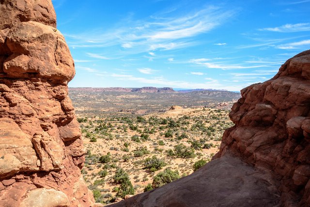 This view from Arches National Park, Utah, shows a landscape typical of one of the more protected natural areas of the Colorado Plateaus. Vegetation is sparse, consisting mostly of small, woody shrubs interspersed with open space. The bottomlands are relatively flat, but the distance shows steep-walled mesas and plateaus. Photo © Domenico Convertini, CC BY-SA 2.0, Source.