
Home » Regions » North America » North American Deserts » Cold Deserts » Arizona/New Mexico Plateau
Arizona/New Mexico Plateau
Last updated: August 8th, 2023
Page contents
To check where a specific point lies, you can look it up in our Ecoregion Locator.
↑Map Legend & Subregion List
This list will help you navigate the regions in case you have problems with viewing or clicking the interactive map above.
† Status: ✓ = Complete ○ = Needs Image … = Incomplete ∅ = Stub Only
‡ This code refers to the US EPA's Level 4 ecoregion codes for the continental U.S., see here.
↑Progress
Partially Complete | With Images | Complete w/ Images |
Get involved! You can help our ecoregion articles progress faster. Help us find photos of these regions. Contact us if you have any additions or corrections to any of these articles. You can also donate to support our ongoing work.
↑About the Arizona/New Mexico Plateau
The Arizona / New Mexico Plateau is a region covering much of northern Arizona and northwestern New Mexico, and at its eastern end extending northward into the San Luis Valley in southern Colorado. This region is high enough in elevation to make it cold for its latitude, but is mostly-surrounded by mountains of much higher elevations, creating rain shadow and leading it to also be very dry. Parts of this region are well-known due to the presence of the Grand Canyon here, but this region is much larger and includes areas with vastly different topography as well. The landscapes which are both varied and highly visible due to the lack of vegetation has made this region a favorite subject for artists.The climate here ranges from a cold desert climate to the dry end of a mid-latitude steppe (semiarid) climate. Summers tend to be hot and have very low humidity, and winters range from cool to cold, and are also dry. There are large temperature swings throughout the day, but temperatures are relatively predictable from day-to-day, with this region relatively insulated from the typical continental weather patterns caused by the movement of large air masses, although hotter or colder spells are possible at all times of year. The temperature and length of the frost-free period varies considerably throughout the region.
Precipitation here seasonal; there is a wetter season from July through September, extending slightly into October in the southeast of the region, wheareas the rest of the year has some precipitation on average, but less than the wet season. The western parts of the region also have a dry season from April through June, whereas the eastern parts have more consistent drier rest of the year, from November through June. Some of the winter precipitation falls as snow, but snowfall does not accumulate much since daytime temperatures tend to consistently reach well above freezing even in the coldest months. Precipitation also varies greatly from year to year, and can be dependent on large, somewhat random events. The weather averages cooler and wetter in El Niño years and warmer and drier during La Niña years, but the effect here is smaller than in some regions of the southwest; the influence of this cycle is stronger in the south of this region. This region is in the process of becoming drier largely due to a combination of human-induced climate change and unsustainable use of water for the human population here and in nearby regions, which has surged in recent years.
The terrain here is varied, including plateaus, mesas, buttes, steep-walled canyons and cliffs, broad, flat valleys, and irregular plains. The landscape is diverse on most spatial scales. This region has an extraordinarily diverse geology, with bedrock spanning almost the entire length of the Earth's geologic history found near the surface and often exposed as outcroppings. Sedimentary rocks are common, sandstone most common of all, but also with shale, mudstone, limestone, and dolomite, and there are also extensive areas of volcanic rock including basalt and andesite. There are some areas of volcanic cones, especially in the Taos Plateau, and a few elsewhere, but no active volcanoes. Surface soils are also variable in texture, ranging from sandy in places to clay-loam soils with rocky material mixed in. Typical for a desert region, soils tend to be mineral-rich and highly alkaline, with pH averaging well over 8 throughout much of the region, in parts of the region even averaging above 8.5.
There is little water here, with streams being mostly ephemeral or intermittent. A few perennial streams originate in the mountains, mostly in the east of this region. A few large rivers also cross through this region, including the Colorado, San Juan, and Rio Grande. This region spans the continental divide, with the eastern portion draining into the Gulf of Mexico and the west into the Pacific. The Grand Canyon is located at the western edge of this border where the Colorado River cuts deeply through the upper plateau layer.
Large human settlements here are often made possible only through the use of groundwater. The aquifers that water is drawn from are an important source of water for rivers, and the drawing of water by humans through wells has reduced the flow of water in these rivers beyond the volume of water taken directly from the rivers. The Arizona portion of this region has weak protections for groundwater usage as Arizona primarily regulates such usage only around cities and there are no large cities in Arizona's portion of this region.
The vegetation here is sparse; the combination of lack of water and higher elevations with thinner air and large temperature swings makes it hard for plants to survive. The driest, lower elevations support shadscale saltbush (Atriplex confertifolia), fourwing saltbush (Atriplex canescens), greasewood (Sarcobatus vermiculatus), james' galleta (Hilaria jamesii), blue grama (Bouteloua gracilis), and black grama (Bouteloua eriopoda). Higher elevations with slightly more rainfall support pinyon-juniper woodlands, and in the northeast, big sagebrush (Artemisia tridentata), rabbitbrush, winterfat (Krascheninnikovia lanata), western wheatgrass (Pascopyrum smithii), and blue grama. Larger shrubs or trees are only found in a few limited areas such as along major rivers or where groundwater reaches the surface in seeps in sheltered canyons.
This region is more populous than most desert regions, including the major city of Albuquerque and the still sizeable city of Santa Fe, NM. Albuquerque relies on unsustainable drawing of water from aquifers, combined with water taken from the Colorado river. Most of the rest of the region is sparsely populated. There is significant irrigated cropland in the San Luis Valley, and smaller amounts along the Rio Grande and San Juan rivers. The rest of the area is sparsely utilized, with some low-intensity livestock grazing, and some oil and gas extraction and coal mining. There are numerous Native American lands here, and also large areas of protected public land including national parks, national monuments, and public rangeland.
This region is bordered to the north by the Colorado Plateaus, another similar region that has some areas of lower elevation than here, and tends to have fewer grasslands; the border is subjective and represents a gradual transition. To the west is a border with the Mojave Basin and Range, a lower-elevation region that is much hotter and drier and has even sparser vegetation; this border is abrupt and marked by a geologic change and a descent to lower elevations. In the southeast, there is a very small border with the Chihuahuan Deserts, another warmer, drier region. Most of the border to the south is with the Arizona/New Mexico Mountains, a temperate region of higher elevation and rainfall, with more forest cover. In the east of this region, it is interspersed with and sometimes surrounded by the Southern Rockies, a slightly colder region of mountains also with higher rainfall and more forest cover. In the east, it also borders the Southwestern Tablelands, a region marking the beginning of the Great Plains, with slightly higher rainfall, more grass cover, and stronger contintental climate influence.
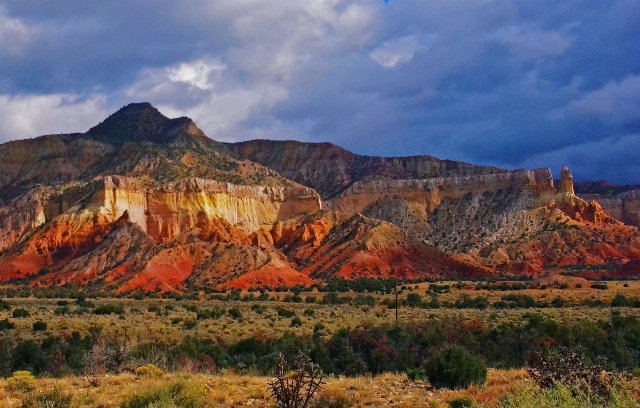 This photo is taken towards the easternmost end of the Arizona/New Mexico Plateau region, and shows nearly-level expanses covered with low grassland with sparse interspersed shrubs, contrasting with a heavily-dissected escarpment leading up to a higher plateau with a rugged, irregular top. These are only some of the many landforms found in this region. Photo © Ron Reiring, CC BY 2.0, Source.