
Home » Regions » North America » Northwestern Forested Mountains » Western Cordillera » Eastern Cascades Slopes and Foothills
Eastern Cascades Slopes and Foothills
Last updated: January 23rd, 2025
To check where a specific point lies, you can look it up in our Ecoregion Locator.
↑Map Legend & Subregion List
This list will help you navigate the regions in case you have problems with viewing or clicking the interactive map above.
† Status: ✓ = Complete ○ = Needs Image … = Incomplete ∅ = Stub Only
‡ This code refers to the US EPA's Level 4 ecoregion codes for the continental U.S., see here.
↑Progress
Partially Complete | With Images | Complete w/ Images |
Get involved! You can help our ecoregion articles progress faster. Help us find photos of these regions. Contact us if you have any additions or corrections to any of these articles. You can also donate to support our ongoing work.
↑About the Eastern Cascades Slopes and Foothills
The Eastern Cascades Slopes and Foothills is a region of mountains to hills and plateaus on the east side of the Cascade Range, where precipitation is lower due to rain shadow. This region is narrow over most of its width, and does not extend to the northernmost reaches of the Cascade Range. In the south, it widens, reflecting the lower elevations of the southern end of the Cascades, as well as greater rain shadow from the taller Klamath mountains to the west. This region corresponds more to ecologically-similar zones rather than geological formations.The terrain here consists of gently sloping mountains, mostly in the west, to high plateaus ranging from flat to hilly. There are volcanic cones and buttes throughout, as well as some relatively recent lava flows. Because of the lower rainfall, the terrain is only weakly dissected, with plateaus featuring isolated canyons through a mostly undissected landscape. The south is largely unglaciated but moving north there are glaical features as well. The bedrock is volcanic, consisting mostly of basalt, andesite, and tuff, with surface deposits of ash, pumice, and cinders that can be thick in some areas. Stream density tends to increase to the north, and there tend to be fewer streams in areas underlain by pumice. Soils here tend to be mostly andisols or mollisols, soils that formed on volcanic ash or under grasslands, respectively. These soils tend to have relatively high fertility and good properties for supporting plant growth.
The climate here is more arid and has greater continental influence than regions to the west; it has attributes of humid continental and Mediterranean climates. Precipitation is strongly seasonal, with wet winters and dry summers, but in spite of the lower total precipitation, summers do receive slightly more rainfall than areas closer to the coast.
This region is covered primarily in open forests of mostly ponderosa pine (Pinus ponderosa), with some lodgepole pine (Pinus contorta). The higher elevations feature douglas-fir (Pseudotsuga menziesii), grand fir (Abies grandis) and white fir (Abies concolor), more characteristic of areas to the west, whereas the lower elevations support sagebrush and steppe, more typical of areas to the east. Wildfire is common throughout much of the region, and frequency and severity of fire is an important mechanism at maintaining the borders between different cover types.
Land use here mostly consists of forestry, livestock grazing, and recreation, including hunting and fishing. This area is mostly sparsely populated. The largest city, Bend, OR, here straddles the eastern border of this region. The largest city entirely contained in the region is Klamath Falls, OR, which was originally a local center for the logging industry. There are also a number of other small towns, and a small amount of Native American tribal land here.
Along most of its length, this region is bordered to the west by the Cascades, which reach to higher elevations and tend to have higher rainfall and denser forest cover. At its very southern end it is bordered to the west by the Klamath Mountains/California High North Coast Range, mountains that reach to higher elevations but are slightly more arid and also have slightly more open cover. In the north there is a small border with the North Cascades, a cool, rugged, high-elevation region. At its southern end this region is bordered by the Sierra Nevada, which also reaches to higher elevations, and has a more Mediterranean-influenced climate and diverse vegetation cover.
The eastern border of this region is more variable. In the north, it is bordered to the east by the Columbia Plateau, a lower, flatter, cold desert region. South of that it is bordered to the east by the Blue Mountains, a partly-wooded region of open mountains. South of that, it is bordered to the east by the Northern Basin and Range, another lower, flatter cold desert region.
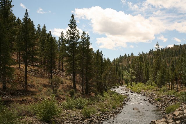 This photo shows the Chewaucan River in Fremont-Winema National Forest, Oregon. This landscape is in many respects typical of the Eastern Cascades Slopes and Foothills, which tends to have hilly terrain, but not the steepest mountains, and is mostly semiarid throughout, supporting mostly open coniferous forests. Photo © U.S. Forest Service, Public Domain, Source.