
Ecoregion-Based Plant Lists and Search
March 30th, 2022 by Alex Zorach
We have published plant lists for particular ecoregions, and related to these lists, added the ability to search for plants within a specific region and see their establishment means (i.e. Native, Introduced, Expanded, etc.) in that region in searches.This is super exciting as it was one of the original goals of bplant.org, and has been years in the making. This post highlights where to find these new features, and how to interpret them and best put them to use. It also explains some of the background work that went into building the lists, including recent progress since our last blog post, and lastly, outlines future improvements and features underway.
Where to Find The Lists and Search
The lists currently are only available for Level 3 ecoregions. You can find these lists from a new "Plants" section listed on each of these region's pages. For convenience, we also linked to the lists for the Level 3 regions on all of the Level 4 subregions, accompanied by a message explaining that we do not yet have the lists for the regions with a finer level of detail.How to Get to These Ecoregion Pages
There are many ways to reach the page for a region. If you want to look up a region at a particular point on a map, you can use our ecoregion locator which is linked to from the footer of every page on our site. You can also browse our state ecoregion maps to see the entirety of the ecoregions in each state. Alternatively, you can explore the whole hierarchy of regions from the Regions tab at the top of our site. Once you are on the page for a Level 3 or 4 region that intersects the continental US, you will see the new "Plants" tab.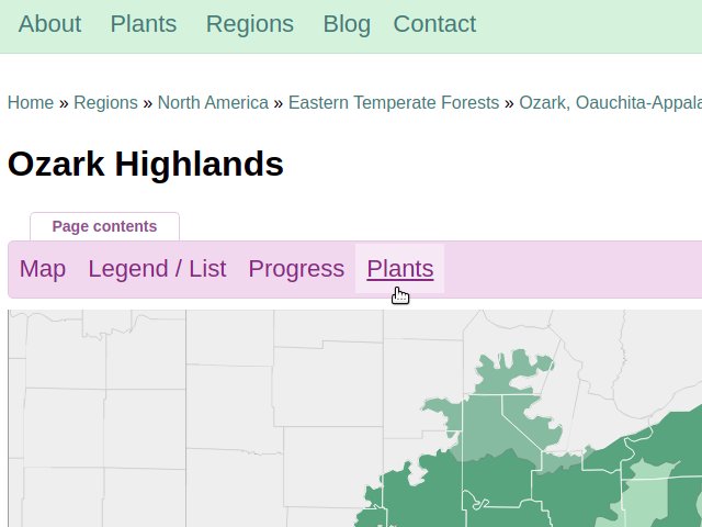 This screenshot shows the new tab visible on the pages for Level 3 and 4 ecoregions in the continental US, which takes you to the new plant lists and search.
Some of the Level 3 regions extend outside the continental U.S., and some of them are completely located outside this region, including in Canada, Alaska, and Mexico. As we have not yet comprehensively built plant range maps into these regions, we do not yet have the data to generate plant lists for these regions.
For regions that are entirely outside the continental US, there are no lists yet. For regions that span part of the continental US but also have significant areas outside of them, we have published lists but with a warning that they are incomplete.
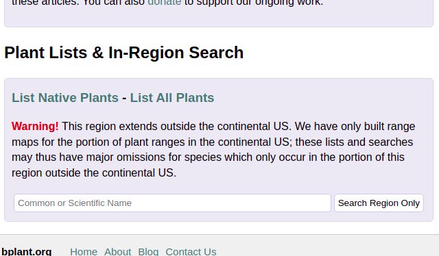 This screenshot shows the new Plants section of the region page, linking to plant lists and also allowing an in-region search. Regions intersecting, but also extending outside the continental US, display this warning.
In-Region Search and Improvements to Search
The in-region search has an exciting new feature, made possible by the fact that you are searching within a specific region: the notation of the plant's status in the region, in the search itself. For example, the following screenshot shows a search for "Magnolia" in the Northern Piedmont. The entries in the "Map" column are color-coded to show the plant's status in the region.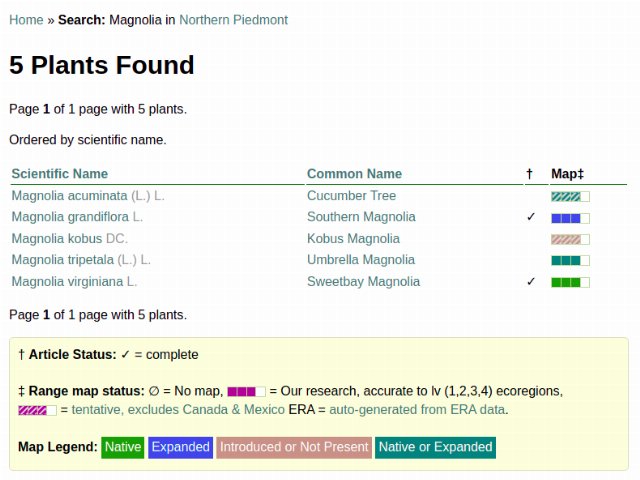 An illustration of the new in-region search with a legend explaining the color codes.
Note that there are now two separate pieces of information communicated in the Map column: both the completeness of the map (with the gray stripes through tentative maps that have not yet been completed for the entirety of North America) and the establishment means for the particular plant in the region. There is a legend at the end of the search, denoting what each color means.
Updates That Made The Lists Possible
Probably the most important progress reflected in these lists is a massive cleaning of the data on the presence/absence, and establishment means (i.e. native, introduced, or expanded) of each plant in each ecoregion.We have also been cleaning up our data on the plants themselves, which includes things such as merging duplicate records (including taxa that have merged due to reclassification), correcting missing and/or erroneous data, and correcting mis-linked data and linking more records to other databases such as USDA PLANTS and BONAP. We have reduced the number of plants in our database to a more manageable 20,579, and may reduce it further as there are still some duplicates and otherwise problematic entries. Both as a result of cleaning out the entries, and completing more maps, a much greater portion of the listed plants now have range maps, and the portion verified for the entirety of North America is also increasing.
How To Use These Lists and Search Results
Keep in mind that, although our level 3 ecoregions are, on average, smaller than most US states, and they do a much better job of corresponding to plant distributions, they are still a coarse instrument. If we mark a plant as present in a region, it means only that it occurs in the wild somewhere in that region; it is not necessarily common (or even present) in all parts of the region. In many cases, such as where plants reach their range limits in a region, plants may only occur in a small portion of each region. This is particularly common for regions that span a long distance.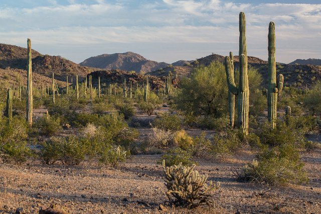 The Sonoran Basin and Range extends from southeast California and much of Arizona well into Mexico, in Baja California and Sonora. Many plants found in this region are only found in a small portion of it. For example, the Saguaro (Carnegiea gigantea) is only found at low elevations, and even there does not extend into Baja California. Public Domain photo by US Bureau of Land Management, Source.
These lists and searches are thus best used only as a starting point and/or an instrument to narrow down your consideration of certain plants. If you are considering choice of plants for an ecological restoration project or garden, you will still need to do additional work to determine the plant's range and status in your area, on a finer-tuned level.
To this end we recommend checking the BONAP and/or USDA PLANTS county-level range maps (When both exist, BONAP is usually more accurate), which we have linked to from the "Links" section in each article, for convenience. You may also want to use regional sources, such as Calflora, the Maryland Plant Atlas, or whatever other state and regional resources are suitable for your area.
If our article on a particular plant is complete, you may also find information about its distribution either in notes written under the range map itself, or in the "Habitat" section, which leads into our next consideration. Check the links section to see what is listed; there may even already be some links to other regional resources. Even if a plant occurs broadly in your region, it will only occur in certain habitats.
Future Improvements
The current state of our plant lists is only a beginning. In the future we aim to add a number of features, including:- Expanding our data to include ecoregions outside the continental US
- Adding higher levels of detail, such as level 4 ecoregions
- Allowing generation of lists and searches for lower levels of details or aggregate regions, such as the level 1 or 2 ecoregions.
- The filtering of plants by various characteristics, including taxonomy (such as plant families or other broad groupings), a plant's growth habit or form (i.e. Tree / Shrub / Perennial / Biennial / Annual / etc.) or habitat preferences (i.e. wetland/upland or moisture preferences, sun/lighting conditions, soil types, etc).
- The display of establishment means (Native/Introduced/Expanded/etc.) on general searches, for those plants that have a single status type in the entirety of North America.
Until then, please enjoy what we have already published!
Archive of All Blogs
How To Identify Plants, May 7th, 2026
The Bias Against Tall Plants, November 11th, 2025
A Focus on Goldenrods (Solidago sp.), July 23rd, 2025
Disturbance and its Role in Plant Habitat Preferences, May 29th, 2025
What "Native" or "Introduced" Mean: Myths and Misconceptions, March 11th, 2025
Smarter & More Informative Search Results, January 13th, 2025
The Effect of the 2024 US Election on Plant Biodiversity and bplant.org, October 30th, 2024
The Problems With Nursery-Bought Plants, And The Solutions, October 8th, 2024
More Databases Linked & Search Improvements for Scientific Names, July 9th, 2024
Choosing The Best Common Names For Plants: Challenges & Solutions, April 19th, 2024
Range Map & Taxonomic Update Progress, January 31st, 2024
Giving Thanks To Everyone We Rely On, November 22nd, 2023
Thinking More Deeply About Habitat, April 5th, 2023
2022 Year-End Summary: Successes & New Goals, February 15th, 2023
New Databases Linked: Flora of North America & NatureServe Explorer, November 11th, 2022
All Range Maps 2nd Generation, Taxonomic Updates, & Fundraising Goal Met!, September 29th, 2022
More Range Map Improvements, POWO Interlinking, And Notes Fields, June 7th, 2022
Ecoregion-Based Plant Lists and Search, March 30th, 2022
Progress Updates on Range Maps and More, February 10th, 2022
The Vision for bplant.org, December 9th, 2021
New Server: Software & Hardware, August 30th, 2021
More & Improved Plant Range Maps, July 19th, 2021
A Control Section for Invasive Plants, April 15th, 2021
Progress Bars & State Ecoregion Legends, March 11th, 2021
Our 2020 Achievements, February 9th, 2021
Interlinking Databases for Plant Research, November 11th, 2020
A New Homepage, Highlighting Our Articles, July 29th, 2020
A False Recovery, But North Carolina's Ecoregions are Complete!, June 9th, 2020
We're Back After COVID-19 Setbacks, April 3rd, 2020
Help Us Find Ecoregion Photos, February 27th, 2020
What We Achieved in 2019, December 30th, 2019
Plant Comparison and ID Guides, October 30th, 2019
We Are Now Accepting Donations, October 14th, 2019
US State Ecoregion Maps, New Footer, Ecoregion Article Progress, and References, September 19th, 2019
Tentative Range Maps of Native Plants, August 12th, 2019
Ecoregion Locator and Interactive Maps, July 10th, 2019
Using Ecoregions Over Political Boundaries, May 13th, 2019
How We Handle Wild vs Cultivated Plants, April 16th, 2019
A Blog To Keep People Updated On Our Progress, April 8th, 2019
Sign Up
Want to get notified of our progress? Sign up for the bplant.org interest list!