
Tentative Range Maps of Native Plants
August 12th, 2019 by Alex Zorach
Range maps, showing the regions where a plant species is native, and those where it is introduced, are a key feature of plant websites. These maps are important to gardeners, landscapers, and people doing ecological restoration work, who often wish to favor native vegetation. The maps help people decide which species to plant and which to remove.We are excited to announce the publishing of tentative range maps of 5660 plants native to the continental U.S. The maps have some shortcomings and inaccuracies, and omit many species, but we hope that even as-is, they are an improvement over what is currently available on other websites, primarily because they are organized by ecoregion rather than political boundaries.
These maps will also serve as a foundation to build on, by adding greater detail, updating the maps for accuracy, and making distinctions in a plant's native vs. introduced status not made by existing databases.
We have redesigned the layout of the plant pages both to include the range maps, and also feature a photo and brief summary of each plant.
 The new plant pages have a multi-column layout on desktop browsers, collapsing to a single-column layout on mobile devices. The full-page layout features a photo, brief summary, and range map in a narrow left column, with the remainder of the article in the main column.
Where did the data come from?
The data for our range maps was taken from the Federal Highway Administration's Ecoregional Revegetation Application (FHWA ERA), a tool intended to help people select native plants for ecological restoration purposes. Although the ERA contains a wealth of data, its search features are limited: one can generate lists of plants by region, but cannot use it to generate range maps for specific plants. The data is also viewable only in a wide-table format that is not ideal for researching a specific plant.Our starting range maps can be seen as a new way of visualizing the data from the ERA, in a way that focuses on each specific species.
Limitations of the ERA data
Our spot-checking of the ERA data has turned up several limitations:- It only covers native, not introduced species.
- Many important native species are missing.
- Data is only for the U.S., not Canada or Mexico.
- Ranges are systematically overestimated in multiple ways.
How does the ERA data overestimate range maps?
The ERA data was generated using county-level data in the USDA PLANTS database. Plants are marked as native to an ecoregion in the ERA if the USDA PLANTS database records them as native to at least one county intersecting that region. Although in a few cases the ERA data has corrected obvious errors in the USDA data, there are several widespread problems remaining:- The USDA PLANTS Database distinguishes between plants native to North America and introduced in North America, and sometimes more specifically in the U.S. vs. Canada, but it does not distinguish between plants native to part of the continental U.S. and introduced in other localities.
An example of this would be how the ERA data marks Common Milkweed (Asclepias syriaca) as native to the Cascades and Williamette valley in the Pacific northwest, whereas this plant is introduced there, even though it is native to the continental U.S. Numerous such examples exist. - Some ecoregions cover a large geographic area, and even if the range map accurately notes that a plant occurs in the region, it may only occur in a small portion of it. This leads plant ranges to be overestimated at the edges of its range, especially where the regions extend far outside the plant's range.
A region where this frequently occurs is the Northern Glaciated Plains, which extends from southern Alberta and Saskatchewan southeast into South Dakota; plants reaching their northwestern limit in South Dakota thus end up with a range map extending into Alberta and Saskatchewan, even when they do not occur anywhere near there. - Some counties intersect multiple ecoregions, and, especially for isolated records of plants in a single county, this results in plants being marked as native to multiple ecoregions when they may not occur in all of them. This problem is common in western states with large counties spanning many ecoregions.
- A few of the entries in the USDA database are of dubious origin and may be outright wrong. For example, the USDA marks common milkweed as native to Texas, but other sources said that the report was unconfirmed and we could find no other reports that the species even occurs, let alone is native, anywhere in the state.
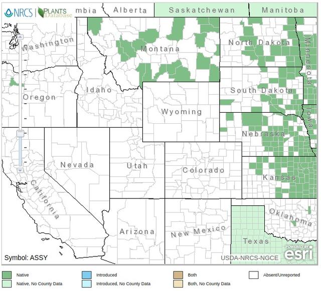 The USDA PLANTS map for Common milkweed (Asclepias syriaca) showcases the interacting factors leading to gross overestimation of plant ranges. Most of the Montana counties are probably errors, as BONAP shows the species not even found in most of those counties. The western parts of the range, reaching as far as Oregon, are easily verified as introduced populations, but the USDA marks these as "Native". These western counties intersect multiple ecoregions, resulting in the plant being wrongly marked as native to all regions intersecting any of those counties, and the regions themselves extend far outside the borders of these counties into areas where the plants have never been reported.
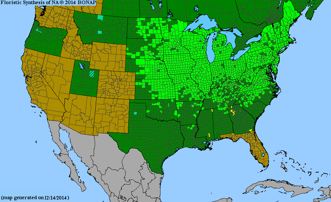
Treat our tentative range maps with caution, and consult external sources.
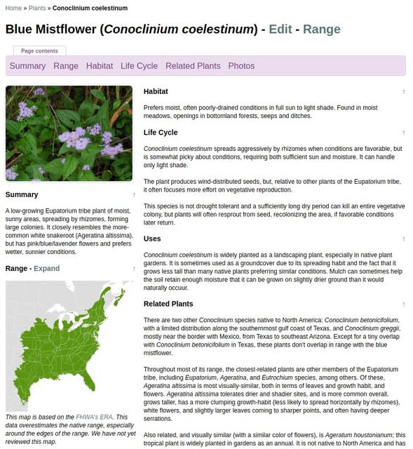
Because of these limitations, we recommend treating these range maps with caution, especially around the edges of ranges, before concluding that a particular plant is actually native somewhere. We have a written note under any range maps that were auto-generated and have not yet been thoroughly reviewed, warning people of these issues and linking to this post.One of the best supplemental resources for plant distribution and native status is BONAP's county-level maps, which in many cases are more accurate than the USDA PLANTS database. Plants of the World Online (POWO) also includes coarse data for the native vs introduced status of plants worldwide, including data breaking Mexico into several broad regions.
Building Off These Maps
These maps are only a beginning, a framework we are using to jump-start the process of building more accurate maps. We are already well underway developing a tool to manage the maps in a time-efficient manner, and we have several concrete plans to improve the maps:- Building maps for introduced species and native species omitted from the ERA.
- Addressing areas where plants are native to the U.S. but have been introduced or expanded their range locally, as the USDA fails to make this distinctions.
- Adding more geographic detail - The ERA-based maps use level 3 ecoregions, whereas we have data on level 4 ecoregions. A finer level of detail can fine-tune geographic boundaries and also track plants whose range or native status is limited by other ecological factors that correspond to ecoregion boundaries, such as altitude, soil type, or topography.
- Investigating cases where isolated counties led to multiple ecoregions being marked, and determining which of these regions the data is relevant to.
- Expanding maps into Canada and Mexico.
Check Out What We Have!
To explore our range maps, type the common or scientific name for any plant species native to North America into the search box at the top of the page. We currently have 6159 species listed, and of those, nearly 92% have tentative range maps.By searching for pages, you will help give us data on which plants people are most interested in, which will help us know which plants to prioritize. You can also contact us with your requests!
Archive of All Blogs
How To Identify Plants, May 7th, 2026
The Bias Against Tall Plants, November 11th, 2025
A Focus on Goldenrods (Solidago sp.), July 23rd, 2025
Disturbance and its Role in Plant Habitat Preferences, May 29th, 2025
What "Native" or "Introduced" Mean: Myths and Misconceptions, March 11th, 2025
Smarter & More Informative Search Results, January 13th, 2025
The Effect of the 2024 US Election on Plant Biodiversity and bplant.org, October 30th, 2024
The Problems With Nursery-Bought Plants, And The Solutions, October 8th, 2024
More Databases Linked & Search Improvements for Scientific Names, July 9th, 2024
Choosing The Best Common Names For Plants: Challenges & Solutions, April 19th, 2024
Range Map & Taxonomic Update Progress, January 31st, 2024
Giving Thanks To Everyone We Rely On, November 22nd, 2023
Thinking More Deeply About Habitat, April 5th, 2023
2022 Year-End Summary: Successes & New Goals, February 15th, 2023
New Databases Linked: Flora of North America & NatureServe Explorer, November 11th, 2022
All Range Maps 2nd Generation, Taxonomic Updates, & Fundraising Goal Met!, September 29th, 2022
More Range Map Improvements, POWO Interlinking, And Notes Fields, June 7th, 2022
Ecoregion-Based Plant Lists and Search, March 30th, 2022
Progress Updates on Range Maps and More, February 10th, 2022
The Vision for bplant.org, December 9th, 2021
New Server: Software & Hardware, August 30th, 2021
More & Improved Plant Range Maps, July 19th, 2021
A Control Section for Invasive Plants, April 15th, 2021
Progress Bars & State Ecoregion Legends, March 11th, 2021
Our 2020 Achievements, February 9th, 2021
Interlinking Databases for Plant Research, November 11th, 2020
A New Homepage, Highlighting Our Articles, July 29th, 2020
A False Recovery, But North Carolina's Ecoregions are Complete!, June 9th, 2020
We're Back After COVID-19 Setbacks, April 3rd, 2020
Help Us Find Ecoregion Photos, February 27th, 2020
What We Achieved in 2019, December 30th, 2019
Plant Comparison and ID Guides, October 30th, 2019
We Are Now Accepting Donations, October 14th, 2019
US State Ecoregion Maps, New Footer, Ecoregion Article Progress, and References, September 19th, 2019
Tentative Range Maps of Native Plants, August 12th, 2019
Ecoregion Locator and Interactive Maps, July 10th, 2019
Using Ecoregions Over Political Boundaries, May 13th, 2019
How We Handle Wild vs Cultivated Plants, April 16th, 2019
A Blog To Keep People Updated On Our Progress, April 8th, 2019
Sign Up
Want to get notified of our progress? Sign up for the bplant.org interest list!