
Home » Regions » North America » North American Deserts » Cold Deserts » Columbia Plateau
Columbia Plateau
Last updated: June 23rd, 2022
To check where a specific point lies, you can look it up in our Ecoregion Locator.
↑Map Legend & Subregion List
This list will help you navigate the regions in case you have problems with viewing or clicking the interactive map above.
| Name | † | Color on Map | EPA Code‡ |
| Channeled Scablands | ○ | 10a | |
| Loess Islands | ○ | 10b | |
| Umatilla Plateau | ○ | 10c | |
| Okanogan Drift Hills | ○ | 10d | |
| Pleistocene Lake Basins | ○ | 10e | |
| Dissected Loess Uplands | ○ | 10f | |
| Yakima Folds | ○ | 10g | |
| Palouse Hills | ○ | 10h | |
| Deep Loess Foothills | ○ | 10i | |
| Nez Perce Prairie | ○ | 10j | |
| Deschutes/John Day Canyons | ○ | 10k | |
| Lower Snake and Clearwater Canyons | ○ | 10l | |
| Okanogan Valley | ○ | 10m | |
| Umatilla Dissected Uplands | ○ | 10n |
† Status: ✓ = Complete ○ = Needs Image … = Incomplete ∅ = Stub Only
‡ This code refers to the US EPA's Level 4 ecoregion codes for the continental U.S., see here.
↑Progress
Partially Complete | With Images | Complete w/ Images |
Get involved! You can help our ecoregion articles progress faster. Help us find photos of these regions. Contact us if you have any additions or corrections to any of these articles. You can also donate to support our ongoing work.
↑About the Columbia Plateau
The Columbia Plateau is a large, relatively flat region covering much of central to southeast Washington State, part of north-central Oregon, and reaching slightly into northwest Idaho and British Columbia. Most of the region is located in Washington state. This region is a drier, low-elevation island surrounded by higher-elevation, higher-rainfall mountainous regions.Rain shadow from the Cascades to the west leads this region to have an arid to semi-arid climate typical of mid-latitude deserts to mid-latitude steppes. The mountains also separate this region from the influence of the ocean, leading to more extreme and unpredictable weather characteristic of continental influence. Precipitation is seasonal; over much of the region, as much as 3 times as much rain falls in winter. Rainfall tends to increase towards the east, and this tends to take the form of the wet season persisting later into spring, a pattern that also increases to the south. In parts of this region, temperature inversions are common in winter, leading to low clouds and dense fog, but this moisture rarely drops much precipitation. The perennial streams and rivers located here originate in adjacent mountainous areas. The remainder of streams are ephemeral, often persisting only for days following a large rain event, and sometimes being dry for years.
The topography here reflects the low precipitation; the terrain has some dramatic gorges and areas of high relief along major rivers, but for the most part the plateau is nowhere as dissected as in higher-precipitation regions. Elevations tend to increase from about 195 ft (60m) above sea level where the Columbia river exits this region in the west, to about 745 ft (227m) along rivers in the east, with the highest hilltops reaching to about 4,920 ft (1,500m.) There are large expanses of flat ground. The terrain has been shaped extensively by a small number of rare, extreme events of massive proportions, including lava flows and massive floods. The floods mostly originated during the end of the last glacial period, when glacial lakes formed by ice melt would break their ice dam and massive volumes of water would flow suddenly into this region. As a result of the lava flows, some portions of this region are underlain by basalt up to 1.1 mi (1.8km) thick. Much of the plateau is covered by deep loess, sediments created when glaciers ground rocks finely enough that they could be carried away by wind. Areas of loess are broken up by rugged scablands and river channels that flow over bedrock. Soils here are mostly formed either on loess or directly on bedrock.
Most of this region is covered in arid sagebrush steppe or grassland. Dominant grasses include bluebunch wheatgrass (Pseudoroegneria spicata), needle and thread (Hesperostipa comata), Sandberg bluegrass (Poa secunda), and idaho fescue (Festuca idahoensis). Dominant sagebrushes include big sagebrush (Artemisia tridentata), including Wyoming big sagebrush (Artemisia tridentata subsp. wyomingensis), and antelope bitterbrush (Purshia tridentata) is also common. A few of the highest hilles and buttes in the east support forests on their steeper, north-facing slopes, and there are also some open forests along the steeper ravines along rivers in the east, but throughout most of the region tree cover is sparse to nonexistant.
This region has been heavily altered and utilized by humans, mainly for agriculture. Cropland here relies heavily on irrigation. There is also significant areas of rangeland and livestock grazing. Major crops here include winter wheat (mainly in the east where rainfall is slightly higher), barley, alfalfa, potatoes, onions, hops, lentils, and peas. There are also extensive areas of fruit orchards and vineyards. Much of the wetlands and marshes along rivers have been drained and utilized for cropland. Humans have also introduced numerous invasive species, and one, cheatgrass (Bromus tectorum), now covers large areas of sagebrush steppe, and has significantly lengthened and worsened the fire season because it dries out earlier than the native vegetation, and its fine leaves facilitate fire spread. There are some areas of military and restricted government land here, as well as public protected land including Columbia National Wildlife Refuge and Hanford Reach National Monument, and there are also some Native American lands.
This area is somewhat populated, much more so than bordering mountainous regions, with some medium-to-small cities located along the major rivers, mostly in Washington, including Kennewick, Pasco, Richland, Walla Walla, and Yakima. Other cities include Lewiston, ID, Hermiston, OR, Pendleton, OR and The Dalles, OR. Parts of this region are sparsely populated to completely unpopulated.
This region is almost entirely surrounded by various portions of the Western Cordillera; all of these areas are higher-elevation and more rugged, and have higher rainfall and thus support forests. To the west, this region borders the Eastern Cascades Slopes and Foothills, which can be seen as a transitional region between this region and the wetter Cascades. In the north, this region is bordered to the west by the North Cascades, a cooler, more northerly portion of the same geologic formation. To the south, this region is bordered by the Blue Mountains, a region of mountains tending to be a bit lower and more open than the Cascades; this region is more similar to here than any of the other bordering regions. To the east and northeast, this region is bordered by the Northern Rockies, a rugged, high-elevation mountain range that is the last range moving eastward to have some maritime influence from the Pacific Ocean at its higher elevations. The only exception to this region bordering mountainous regions is, following the Okanagan River upstream to the north, this region borders the Thompson-Okanogan Plateau, another relatively lower, flatter, and drier region much like this one, also entirely surrounded by mountains, but tending to have a different seasonality of precipitation, instead with wetter summers and drier winters, and tending to have more rugged topography and denser vegetation cover.
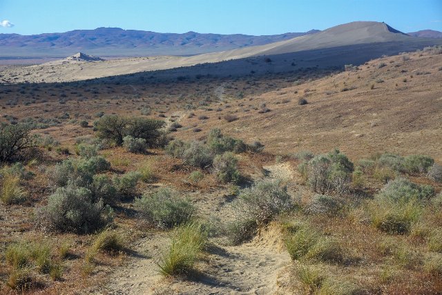 This photo shows a landscape at Hanford Reach National Monument, one of the few undeveloped areas along the Columbia river, showing what land would look like without the intensive irrigated agriculture that is conducted in much of the Columbia Plateau. Photo © USFWS/A. LaValle, CC BY 2.0, Source.
Plant Lists & In-Region Search
List Native Plants - List All Plants
Warning! This region extends outside the lower 48 US. We have only completed range maps for all plants in the lower 48 US; these lists and searches may thus have omissions for species which only occur in the portion of this region outside the lower 48 US.